 Route Editor

| Guide | ♦ | 4 Triplogs | 0 Topics |
details | drive | no permit | forecast | map |
stats |
photos | triplogs | topics | location |
| 8 | 4 | 0 |
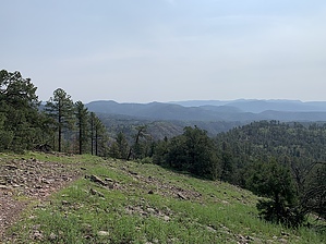
A Stairway to the Blue by FOTG  Warning WarningThe Bear Wallow Fire impacted large portions of the Primitive Blue Range in 2011. Hazardous conditions remain. Trail conditions can change quickly due to winter blowdowns, deadfall, and erosion. Summer monsoons can bring torrential rain and high-intensity storms. Plan accordingly and remain vigilant. Overview Red Hill Trail #56 offers superb views of the heart of the Blue Range as it descends 2,000 feet on the way to its terminus at the Tutt Creek Trail. Blue landmarks such as Bear Mountain, Bell Rock, Castle Rock, the Devil's Washboard area, along with all of the major mesas and deep canyons of the Blue, can be seen from this lesser traveled trail. There is no reliable water along the Red Hill Trail, and there are no facilities apart from an informational kiosk and register at the trailhead.
From the trailhead parking lot, start on a well-maintained trail that begins in a healthy, seemingly manicured forest before hitting a short stretch of forest in recovery from prior logging and fire. At a half-mile and after a short climb, the first extensive views of the Blue emerge, and the descent begins. The Red Hill Trail descends a series of ridges and flat mesas that resemble a series of stairs and steps. At approximately three miles, the trail gains slightly as it passes over its namesake, Red Hill. From Red Hill, the trail continues its long descent to Bush Creek. Once the trail reaches Bush Creek, it continues downstream to its intersection and ending with the Tutt Creek Trail. Check out the Triplogs. Leave No Trace and +Add a Triplog after your hike to support this local community. One-Way Notice This hike is listed as One-Way. When hiking several trails on a single "hike", log it with a generic name that describes the hike. Then link the trails traveled, check out the example. | |||||||||||||||||||||||||||||||||||||||||||||||||||||||||||||||||||||||||||||


