 Route Editor

| Guide | ♦ | 3 Triplogs | 0 Topics |
details | drive | no permit | forecast | 🔥 route |
stats |
photos | triplogs | topics | location |
| 7 | 3 | 0 |
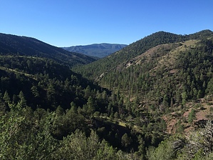
  Details by Apache - Sitgreaves NF Details by Apache - Sitgreaves NFHere's a scenic trail that starts from the bottom of the Blue instead of from the top. You can hike any of the rim-to-river Blue Trails from the canyon floor as well as from the rim, but this one is made for it. Starting at the bottom means you're in a desert environment right from the beginning. A good part of this trail is actually in a riparian or streamside habitat rather than a desert. Here you'll find narrowleaf cottonwood and a few well-off old ponderosa rather than cactus. Even when the trail climbs a saddle or follows a ridge, it's not in the same type of desert most people think of when they think of Arizona -- no saguaros, but you may see a Greater Roadrunner. On the lower hillsides and ridges of the Blue, the most noticeable vegetation is juniper trees. Look underneath them and in the exposed areas on dry hillsides, and you will see some cacti, mostly prickly pear and an occasional cholla. You'll also see wildflowers. Desert wildflowers are best in the spring. Look for various kinds of paintbrush and prickle poppies. There are several different kinds of hedgehog cacti here too, with some of the brightest blooms you'll see anywhere. Watch for movement among the rocks too. This area is home to a herd of Rocky Mountain Bighorn sheep.
Notes: No mechanized vehicles (including mountain bikes) permitted in the Primitive area Cleveland Spring and the various creeks in the area provide water suitable for stock animals only unless it's filtered or treated Trail Log: 0.0 Junction with Red Hill Road, Forest Road 567 0.8 Follow jeep trail to the junction with Bush Creek. Trail crosses Bush Creek at this point and enters mouth of Tutt Creek 2.1 The trail leaves Tutt Creek and ascends a ridge to the left 3.2 Crosses saddle on the ridge. Old wood stock feeder station on right 3.4 Cleveland Spring, developed as a livestock water source 4.2 Junction with Foote Creek Trail #76 at the old wooden corral USGS Maps: Maness Check out the Official Route and Triplogs. Leave No Trace and +Add a Triplog after your hike to support this local community. One-Way Notice This hike is listed as One-Way. When hiking several trails on a single "hike", log it with a generic name that describes the hike. Then link the trails traveled, check out the example. | |||||||||||||||||||||||||||||||||||||||||||||||||||||||||||||||||||||||||||||||||||||||||||||||||||


