Route Editor

| Guide | ♦ | 24 Triplogs | 0 Topics |
details | drive | permit | forecast | route |
stats |
photos | triplogs | topics | location |
| 7 | 24 | 0 |
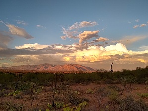
Sombrero's Training Hike by Jim   Sombrero Peak is the steep, rough hike that is relatively popular for hikers to summit year-round for commanding views of the northern Tucson Mountains and surrounding area. It makes a great training hike if you have the time. However, if it requires more time than you may have, and it is in bad shape following rain, and during dry periods, this option exists. So, if you still want to use the Sombrero hike to train, you can get to the base of the cliffs that face due east and enjoy a decent 75 to 90-minute training hike. Sombrero Peak is the steep, rough hike that is relatively popular for hikers to summit year-round for commanding views of the northern Tucson Mountains and surrounding area. It makes a great training hike if you have the time. However, if it requires more time than you may have, and it is in bad shape following rain, and during dry periods, this option exists. So, if you still want to use the Sombrero hike to train, you can get to the base of the cliffs that face due east and enjoy a decent 75 to 90-minute training hike.This hike is identical to Sombrero, but you are not going around the summit to ascend the last steep slopes, which is also where the steepest and loosest sections seem to be, generally. There is also no scramble on this hike.
However, if you want, you can make a shorter loop of about 1.75 miles and 400' of AEG by hiking down towards and through the cove to exit, skipping the hike up to the cliff face. This seems to be rather popular with more pedestrian hikers, and if rain threatens, it is a good bail-out option. Assuming you want the full cliff face training option, observe the obvious trail which heads upslope towards the cliffs and hike it! Up you go, with the usual heart pumping and legs flailing about, like some cartoon hiker. Probably not. Once you near the cliff face, the trail starts to level out a bit. It does go up slightly more later on before dropping down, but you lose the east and northeast views. This is where I turn around, and you can, too. Descend the way you came, or go through the Cove, shaving about 1/4 mile and 100 feet of AEG off your hike, if you do.
Check out the Official Route and Triplogs. Leave No Trace and +Add a Triplog after your hike to support this local community. | ||||||||||||||||||||||||||||||||||||||||||||||||||||||||||||||||||||||||||||||||||