Route Editor

| Guide | ♦ | 1 Triplog | 0 Topics |
details | drive | no permit | forecast | route |
stats |
photos | triplog | topics | location |
| 12 | 1 | 0 |
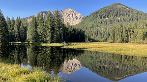
Down south up north from east to west by chumley Hike: Begin the hike at the Medicine Lake Recreation Area. The sign at the trailhead indicates this loop to be 10.8 miles. The route followed here matches that on the trailhead map and was a mile and a half shorter. I'm not sure where the discrepancy lies.
Trail #081 ends at the junction of South Mtn Trail #029. Downhill is open to mountain bikes and connects with Burlfriends Trail #088 to loop back to La Sal Pass. Uphill is the route to take for the South Mtn Loop and is not open to mountain biking. The first couple hundred yards on #029 is stupidly steep, for no apparent reason, other than perhaps to intentionally dissuade mountain bikers from attempting it. The grade moderates, but the 900-foot climb continues until reaching a saddle at 2.4 miles. This is the high point of the loop at over 10,700 feet. (Peak baggers seeking to reach the summit of South Mountain will head off-trail up the ridge from here). The next two miles traverse across the southern slopes of South Mountain, dropping about 600 feet before climbing back up about 300. This section of trail features dense aspen forests and open glades and avalanche paths. These south-facing glades feature great views, but also lack shade and can get quite warm in summer. From the saddle at 4.25 miles on the southwest corner of the loop at 10,300 feet, the trail climbs a bit more before beginning a very steep 1000-foot descent in a dense north-facing drainage utilizing numerous tight switchbacks. The transition from south-facing aspen forests to a sheltered north-facing conifer forest is noticeable and enjoyable. As the descent ends at about 5.6 miles, the trail forks with Crows Foot #075 heading downhill toward Pack Creek #041. Staying on the South Mtn Loop is a much more worn route and one could miss the unsigned junction and apparently lesser-used Crows Foot trail if not looking for it. Continuing to traverse around the west side of the loop, the trail soon crosses Pack Creek at the 6.6-mile mark, a small perennial stream that provides a reliable source of water. From the creek crossing, the trail climbs about 400 feet over the next half mile before reaching the junction with Terraces Trail #080. From here it's about .75 miles to reach the trailhead at the end of Forest Road 0237, a mile on the pleasant 0237 two-track to La Sal Pass, and another half mile back to the Medicine Lake Trailhead. Check out the Official Route and Triplog. Leave No Trace and +Add a Triplog after your hike to support this local community. | |||||||||||||||||||||||||||||||||||||||||||||||||||||||||||||||||||||||||||||||||||||