Route Editor

| Guide | ♦ | 2 Triplogs | 0 Topics |
details | drive | permit | forecast | route |
stats |
photos | triplogs | topics | location |
| 21 | 2 | 0 |
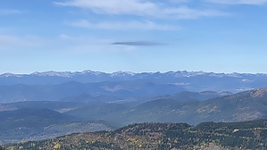
summer squitoe hordes rejoice by LindaAnn Hike: Starting from the Trail# 52/161 trailhead, head north on Lake Darling Trail #52 from the northwest edge of the parking area. The trail generally heads north, then northeast, gently gaining elevation as you head up to Lake Darling.
The trail then curves west around the north edge of the lake, crossing boardwalks in the boggy places, before starting to head more steeply uphill. Vegetation encroaches on the trail for about a mile once you get past the lake. It's mildly annoying in the autumn, and likely more annoying in the summer when leafed out. The trail gets steeper and rockier as it approaches the Pend Oreille Divide Trail #67. The tradeoff for the steepness is the vegetation finally clears away from the trail. Once the Pend Oreille Divide Trail, take a moment to enjoy the views to the west from the rocky outcropping just above you. After that, head north (right) on the Divide Trail, where Mount Pend Oreille is clearly visible ahead of you. Unlike the heavily treed Lake Darling Trail, the Divide Trail has few trees, so there are great views in all directions as you make your way uphill. After a quarter-mile on the Divide Trail, the trail splits. There is a sign, but it was laying on the ground as of Oct 2021. Take the right fork to head up to the summit of Mount Pend Oreille. You have just under half a mile to go to reach the summit, but it is quite steep and rocky, gaining nearly 500'. The trail makes its way up the west slope of the summit, before turning sharply to the right for the final approach. The views in all directions are amazing, and the summit has a broad flat area, with the highpoint being a rocky outcropping towards the east side. The Cabinet Mountains in both Idaho and Montana are visible to the south and east. The Purcell Mountains are visible to the north. The Selkirks of both Idaho and British Columbia dominate the western horizon, and the Selle Valley is below you to the west. Lake Pend Oreille and the town of Sandpoint are visible to the southwest. Once done, retrace your steps back downhill. The return hike is quite easy and goes by quickly. Check out the Official Route and Triplogs. Leave No Trace and +Add a Triplog after your hike to support this local community. | |||||||||||||||||||||||||||||||||||||||||||||||||||||||||||||||||||||||||||||||||||||||||