The Watershed Trail #299 is part of the Prescott Circle Trail and runs from the Senator Highway to forest road 52A in 3.2 miles. It is partially shaded and provides some views. It is a wide gravel and dirt path accessible to hikers, mountain bikers, horses, motorcycles, and ATVs. We hiked on a Wednesday and didn't see any other users. The trail offers several options for a hike: (1) hike to FR52A and return, (2) hike to Spruce Mountain summit via this trail and FR52A and return, (3) hike to Walker Road via this trail and the Seven Mile Gulch Trail #9854 one way with a car shuttle or round trip, or (4) hike to Walker Road via this trail, FR52A and the Smith Ravine Trail #297 one way with a car shuttle. PDF View
The Hike. The trail begins on the left side of the parking area which is large enough for several cars. There is a fiberglass forest service sign marking this point. The trail immediately begins to climb and continues up at a moderate incline for the next 1.5 miles gaining 700 feet of elevation. At 0.6 miles (N34 29.957 W112 25.902) there is a concrete basin for Deer Lick Spring to the right of the trail which had water in it when we hiked in Aug 2009. At 1.2 miles there is the junction with the Seven Mile Gulch Trail #9854 (N34 30.207 W112 25.526). At about 1.5 miles the trail levels briefly and you begin to see views to the east through the trees. From here to the end of the trail you are walking on an undulating ridge. At 2.7 miles you come to a powerline tower (N34 29.211 W112 25.062) and begin a steep 0.1 miles climb to another powerline crossing beyond the next tower. From here it is 0.4 miles down to the junction with FR52A at N34 28.916 W112 24.945.
At this point, you can return to the trailhead for a total of 6.4 miles and 1,405 feet of accumulated elevation gain (AEG). We felt energetic the day we did the hike so opted to continue on FR52A to the summit of Spruce Mountain. This is a road walk past private cabins on a well-graded road accessible to family sedans. It isn't super interesting but provides some nice views, access to the summit, and a good workout. To do this turn left on FR52A and follow it to the summit. At about 4.0 miles from the trailhead, you get good views of the summit of Spruce Mountain to the right with the fire tower very evident. At 4.4 miles you come to the junction with the Smith Ravine Trail #297 (N34 28.490 W112 24.058) on the left. The road becomes steeper beyond this point. At 5.2 miles you reach the gate (N34 27.830 W112 24.027) and at 5.7 miles you reach the junction with the Groom Creek Loop (#307), access to the tower trail, picnic tables, and an outdoor bathroom. The entire round trip from the trailhead to the summit and back is 11.36 miles and 2,395 feet AEG.
Gate Policy: If a gate is closed upon arrival, leave it closed after you go through. If it is open, leave it open. Leaving a closed gate open may put cattle in danger. Closing an open gate may cut them off from water. Please be respectful, leave gates as found. The exception is signage on the gate directing you otherwise.
When hiking several trails on a single "hike", log it with a generic name that describes the hike. Then link the trails traveled, check out the example.
WARNING! Hiking and outdoor related sports can be dangerous. Be responsible and prepare for the trip. Study the area you are entering and plan accordingly. Dress for the current and unexpected weather changes. Take plenty of water. Never go alone. Make an itinerary with your plan(s), route(s), destination(s) and expected return time. Give your itinerary to trusted family and/or friends.
Only trailheads with six "amenities" have fees. Amenities are picnic tables, trash, toilet, parking, interpretive signing and security.
Directions
Road
Paved - Car Okay
To hike To access the trailhead from downtown Prescott, travel east on Gurley Street for 0.3 miles to Mt. Vernon Avenue. Turn south on Mt. Vernon and continue for 4.1 miles as it becomes the Senator Highway. The TR 299 (Watershed Trail) trailhead is on the east (left) side. It is about 0.5 miles past the access road to Goldwater Lake as you travel from Prescott.
 Route Editor


 The Watershed Trail #299 is part of the Prescott Circle Trail and runs from the Senator Highway to forest road 52A in 3.2 miles. It is partially shaded and provides some views. It is a wide gravel and dirt path accessible to hikers, mountain bikers, horses, motorcycles, and ATVs. We hiked on a Wednesday and didn't see any other users. The trail offers several options for a hike: (1) hike to FR52A and return, (2) hike to Spruce Mountain summit via this trail and FR52A and return, (3) hike to Walker Road via this trail and the Seven Mile Gulch Trail #9854 one way with a car shuttle or round trip, or (4) hike to Walker Road via this trail, FR52A and the Smith Ravine Trail #297 one way with a car shuttle. PDF View
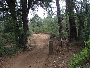


