Route Editor

| Guide | ♦ | 2 Triplogs | 0 Topics |
details | drive | no permit | forecast | route |
stats |
photos | triplogs | topics | location |
| 14 | 2 | 0 |
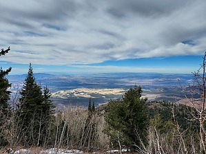
High in Washington County by DixieFlyer Signal Peak (elevation of 10,365 feet and prominence of 4,485 feet) is in southwest Utah, about 15 miles from St. George. Signal Peak is in the Pine Valley Mountains and the Dixie National Forest. It is a Utah county highpoint and it is the 87th most prominent peak in the continental United States. History Signal Peak got its name during World War II when some signal beacons were placed atop the mountain to prevent airplanes from crashing into the mountain at night.
There are two primary starting points for the hike: 1) Forsyth Trail #31012 from the north. The hike from this approach will be 13.3 miles long with 4,200 feet of AEG. 2) Oak Grove Trail #31030 from the east. The hike from this approach will be 9.5 miles long with 4,500 feet of AEG. Forsyth Trail From the Forsyth Trailhead, the trail is fairly open for the first half mile or so; beyond that, the trail will be shaded about 90% of the time all the way to the summit. The shade is nice in hot weather, but it comes at a cost: there are very little in the way of views. The trail goes alongside Forsyth Creek much of the way as you go up a canyon. After about 4 3/4 miles you'll come to the Summit Trail, which you will take to very near the summit. Actually, the last 0.3 miles or so to the summit are not on a trail, per se; instead, you basically head uphill through an open pine forest. There are a few cairns in this section, which help with route-finding, but it is not crucial that a precise route be followed during the final push to the summit. When the author of the guide did this hike, there was snow on the ground on the push to the summit, and a trail would not have been visible anyway. Bear that in mind if you use the guide author's GPS track. The summit is in a flattish area, and the highpoint is on the south side of the summit. There you will see a summit cairn and summit register log. There is a gap in the trees there that offers a bit of a view to the south. There is a steady grade for most of the ascent. For the first 2 miles, the ascent is at a rate of about 500 feet per mile. The trail steepens over the next 3 miles, gaining about 750 feet per mile. Then you'll give up a bit of elevation, only to have to regain it on the final climb to the summit. The road is paved until the last 1/2 mile to the trailhead; the last 1/2 mile is on a flat, well-graded unpaved road that any vehicle can drive on. Oak Grove Trail The Oak Grove Trail starts adjacent to Oak Grove Campground. The first 3 miles of the hike are very steep, gaining about 3,300 feet over 3 miles. For the next 2 miles, the trail flattens out and hits the Summit Trail, before making a final ascent to the summit. There is quite a bit of sun exposure on the first 3 miles of the ascent, and you'll be catching the full brunt of the morning sun. There are some nice views to be had though, particularly of the red rocks of Snow Canyon State Park, and you can even see a bit of Zion off in the distance. Given the sun exposure, hiking from the Oak Grove Trailhead is more enjoyable in the fall of the year. The last 9 miles to the trailhead are on an unpaved road that is generally well-graded. In dry weather, most vehicles can make the drive, although there are a couple of hills to pull so an SUV would be preferable to a sedan. When to Hike June into November is the best time to do this hike, with September and October being the best times. Synopsis This hike is of particular interest to peakbaggers, although fit hikers will also enjoy it. If hiking in the summertime, hiking from the Forsyth Trailhead is preferable due to the shade cover. When the weather is cooler, the views favor hiking from the Oak Grove Trailhead, assuming that you are a fit hiker and can handle a steep trail. Check out the Official Route and Triplogs. Note This is a moderately difficult hike. Leave No Trace and +Add a Triplog after your hike to support this local community. | ||||||||||||||||||||||||||||||||||||||||||||||||||||||||||||||||||||||||||||||||||||||||||||