 Route Editor

| Guide | ♦ | 5 Triplogs | 0 Topics |
details | drive | no permit | forecast | route |
stats |
photos | triplogs | topics | location |
| 4 | 5 | 0 |
High road to salty views by mt98dew  Warning WarningThough I did not see any restrictions on user access, realize this is a heavily biked area. Hikers, bikers, and equestrians are meant to share the trails, but for every hiker you see you’ll easily encounter 10 bikers. Be wary when hiking. Dogs are not prohibited (to my knowledge) but are not advisable. Overview The Hawes Trail System is a conglomeration of trails that have developed over time to become one of the more popular biking (and hiking) destinations on the east side. Originally starting as social trails created by nearby residents, the trail system has blossomed over the last 6 years, in large part, due to the hard work and dedication of the Hawes Trail Alliance (HTA). This nonprofit organization (through the efforts of volunteer hours and funds raised through the local community and avid users in conjunction with the Tonto National Forest) has worked to maintain existing trails and add new trails to this burgeoning biker “bestination”. Currently, there are at least 32 trails incorporating 62 miles that are accessible from 7 THs. The system is bracketed between Usery Pass Rd, Bush Highway, and Power Rd. There is hope for additional development both in trails and trailheads. Check out the Hawes Trail Alliance website for updates on future plans.
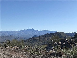
The High Ridge Trails is one of 32 trails in the Hawes Trail System. This is an interior trail so some additional hiking is required. To best access this trail start from the Bulldog TH and hike in on the Lance Trail. (The Bulldog TH is on the east side of Usery Pass Rd. The beginning of the Lance Trail is across the road, just to the north of the wash). To reach the High Ridge Trail, hike 0.58 miles on the Lance Trail. There will be an unsigned split at 0.46 miles. Continue past this split, heading west (stay left) to reach the signed High Ridge juncture. The High Ridge Trail is a solid single track, composed primarily of hard dirt with occasional spots, layered with grus-like gravel. Initially, the trail will take off to the south twisting through hills, before dropping down and crossing a major wash. The trail goes straight across and leaves the wash heading west. It gradually climbs along a saddle with the wash disappearing to the north and mountains rising before you to the south and west. There will be some minor curves as the trail continues to climb and though the distance views are minimal at this time, the vegetation within this valley is a nice assortment of jojoba, bursage, staghorn cholla, palo verde, and saguaros. At 0.52 miles there will be a brief flat spot before starting a series of sharp switchbacks that will gain elevation quickly. This can be a dangerous stretch as bikers will be coming down quickly and views can be restricted by the sudden turns. As you climb the views will open up to the north and east, providing great views of the Salt River Valley and Four Peaks. At 1 mile the trail will flatten out and start to contour along the side of the mountain. At 1.05 the trail will reach a saddle allowing for excellent, but short-lived views to the south. As the trail starts to swing to the north, there will be a small rock outcropping, that one can either climb or switchback up. After the outcropping you are once again hiking along the shoulder of a mountain, so views to the south and west are limited, but you’ll see a large dirt mound off to the north (usually frequented by resting bikers) that represents the end of the High Ridge Trail. The trail will gradually turn toward this destination and will offer one last limited view to the south. The trail ends just below this dirt hill at 1.66 miles. Options are somewhat limited at this point. You can continue north on the Iron Goat for a much larger loop with the ability to connect to multiple trails or do a small lasso, hiking down on the Alp d’ Huez Trail. Realize that, though the trail intersections seem to be well signed, there are no trail maps of the area. Know the trails and the distances involved. Note Currently, there are no fees to use the Hawes Trail System. That may change depending on future developments and the involvement of the Tonto National Forest. Synopsis The Hawes Trail System is a bit removed from the valley but offers a nice variety of trails with varying degrees of difficulty. While Hawes is known primarily as a biking system, it is open to all users. The High Ridge Trail is on the southern edge of the trail system so interaction with other trails is minimal, however, there are some nice, smaller loop options. Though the High Ridge is doable from both directions, most bikers prefer to ride it clockwise because of the elevation change. This nice trail brings some great views from the higher sections. Check out the Official Route and Triplogs. Leave No Trace and +Add a Triplog after your hike to support this local community. One-Way Notice This hike is listed as One-Way. When hiking several trails on a single "hike", log it with a generic name that describes the hike. Then link the trails traveled, check out the example. | ||||||||||||||||||||||||||||||||||||||||||||||||||||||||||||||||||||||||


