username
X
password
register
for free!
help
 
  🔥

Jackson Butte - Sevenmile Mountains, AZ

Guide 1 Triplog  0 Topics
  5 of 5  
Fav
Wish
0
details
drive
no permit
forecast
🔥
route  
stats
photos
triplog
topics
location
0 1 0
HAZ reminds you to respect the ruins. Please read the Archaeological Resources Protection Act of 1979 & Ruins Etiquette
Statistics
tap row or icons for details
Difficulty 3.5 of 5
Route Finding 2 of 5
Distance Round Trip 2.7 miles
Trailhead Elevation 5,042 feet
Elevation Gain 1,064 feet
Accumulated Gain 1,130 feet
Avg Time Round Trip 2.5 hours
Kokopelli Seeds 8.35
 Interest Off-Trail Hiking, Ruins, Historic & Peak
 Backpack Possible - Not Popular
unreported if dogs are allowed
editedit > ops > dogs to adjust
feature photo
Photos Viewed All MineFollowing
49  2022-01-30
Blackjack Jackson
DixieFlyer
Author
author avatar Guides 99
Routes 1,484
Photos 16,072
Trips 1,374 map ( 13,602 miles )
Age Male Gender
Location Fountain Hills, AZ
Associated Areas
list map done
Globe Region
Historical Weather
Trailhead Forecast
Radar Map
Expand Map
Preferred Mar, Nov, Feb, Apr
Seasons   Autumn to Spring
Sun  5:59am - 6:43pm
Official Route
 
1 Alternative
 
Historic Fire Perimeteracres
🔥 2020 Griffin Fire61.8k


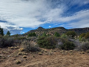
Hotter than a pepper sprout
by DixieFlyer

 
Overview
Jackson Butte (elevation of 6,106 feet and prominence of 1,066 feet) is just off of Highway 60 in Gila County, about 20 miles north of Globe. It is in the Tonto National Forest and is part of the Sevenmile Mountains range.


Hike
From the parking area, Jackson Butte is clearly visible to the west, a little over a mile away. The objective is to first reach a plateau that is on the north side of Jackson Butte, and then make the climb up to the summit on the north slopes of the butte.
remove free decal offer
From the parking area, it is probably best to go south (that is to your left when looking at Jackson Butte from the parking area) for 1,000 feet or so in order to avoid a thicket of cat's claw not far from where you park. Then take a farm road to your right toward Jackson Tank, climb under a barbed-wire fence near the tank, and then head west up toward Jackson Butte. There is some scattered vegetation along the way, but almost all of it can be avoided. After about a mile you will reach a plateau that is about 300 vertical feet below the summit. From there just head toward the summit and make a steep climb up. There are a few outcroppings in the way, but you can skirt around them without much trouble. There is some vegetation to deal with -- mostly shrub live oak and some juniper trees -- but you can work around these for the most part. There is some loose rock in places, so exercise care on these sections.

Once at the summit enjoy the views and check out the interesting ruins that are up there.

Descend the same way that you came up. While descending you will be able to see the airstrip where you parked, so you'll know where you need to go. It is not essential to precisely follow any certain route; just pick the way that looks best to you. If you use the guide author's GPS track, his descent route was better than his ascent.

Warning
There is a fairly steep grade on some portions of the hike, so exercise caution on these sections, especially on the descent. There is some loose rock in places, so be careful where you place your feet. There is a bit of class 2 hiking just below the summit, but there is nothing worse.

2022-01-31 DixieFlyer


    Check out the Official Route and Triplog.
    Leave No Trace and +Add a Triplog after your hike to support this local community.
    WARNING! Hiking and outdoor related sports can be dangerous. Be responsible and prepare for the trip. Study the area you are entering and plan accordingly. Dress for the current and unexpected weather changes. Take plenty of water. Never go alone. Make an itinerary with your plan(s), route(s), destination(s) and expected return time. Give your itinerary to trusted family and/or friends.

     Permit $$
    None


     Directions
    or
     Road
    FR / Dirt Road / Gravel - Car Okay

    To hike
    From Globe, travel 20.6 miles north on Highway 60 to FR 216. Turn left on FR 216, go 0.6 miles, and then turn left onto an old dirt airstrip. There is plenty of parking just after you turn onto the airstrip. GPS coordinates for the parking area are: 33.63167, -110.59963
    Google Maps will get you to these coordinates.
    page created by DixieFlyer on Jan 31 2022 6:29 am
     90+° 8am - 6pm kills
    helpcorrectionissue

    end of page marker