 Route Editor

| Guide | ♦ | 2 Triplogs | 0 Topics |
details | drive | no permit | forecast | route |
stats |
photos | triplogs | topics | location |
| 19 | 2 | 0 |
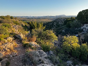
The Gulch to Sedona by mt98dew  Overview OverviewThe Wickiup Mesa Trail System is a group of trails located on the southeast edge of the community of Rimrock. Its creation was through the efforts of the Beaver Creek Trail Coalition, the Forest Service, and Yavapai County. The trail system covers 700 acres and ties into the Wet Beaver Creek Wilderness. It currently only has 6.5 miles of trails composed of 7 different routes. Two trailheads and two access points allow entry to the trail system. The main TH, at the end of Forestglen Rd., is an oddly shaped oval with room for about 10 cars. This is also an entry point for vehicles that want to use the forest service roads, so keep that in mind when parking. There are no bathrooms or water at the TH so come prepared. The TH does have a nice info board with a brief history of the area, wildlife, and foliage. All trails are well-signed and all junctures have trail maps that allow you to see how the trails interact. Hike Golden Gulch trail is part of the Mesa Wickiup Trail System. This trail is designated as one of the entry points into this trail system, but parking at this trailhead is on the shoulder of a private drive and can at best accommodate about three cars. Unless your objective is to hike this trail solely I would recommend starting at the Glen Forest TH. Because of this, I am describing Golden Gulch as if it is an interior trail and that you will need to hike in to reach its southern terminus.
The view from this spot is some of the best that this trail system has to offer, (though to be honest, the competition for great views isn’t that strong). You are looking to the north with a teasing glimpse of the Red Rocks of Sedona, framed by the “canyon” walls of “Golden Gulch”. The trail immediately begins to descend, but at a very gradual incline with multiple flat sections along the way. The “canyon” will slope above you to the west offering some nice rock formations to spice up the trail and on the east side the gulch will descend more rapidly (than the trail) offering some nice, elevated views. This perspective is fleeting though, as the trail remains on a shelf and the gulch’s bottom is lost to an intermediary slope. Still, the views are solid with a sense of intimacy (rewarding for only hiking 1 mile). However, around 0.33 miles the gulch starts to open up, losing that “canyon” feeling, and homes come into view. At 0.43 miles the trail begins to “snake” down a slope losing elevation a little more rapidly. At 0.68 miles the trail crosses over a tributary wash that feeds into the Golden Gulch. Shortly after that, the trail ends at 0.74 miles. Very anti-climatic from the start of the trail. You are now in a valley with limited views and homes encroaching from several directions. The parking for this “trailhead” is through two gates and up a short slope to the west where there is minimal parking. The tail is composed of compact dirt along with infrequent patches of embedded and loose rolling rocks. This is actually a nice change from the other trails in this trail system. The trail does a nice job of maintaining a level track even though a good portion of the path is cut into the side of a slope. Synopsis One of the more pleasant hikes in the Wickieup Trail System. It offers some unique and diverse landscaping because of the gulch and has some decent views towards Sedona at the beginning of the trail. It is an isolated trail so it does force you to do an out and back and the northern end of the trail does approach individual homesteads so the “natural” views begin to diminish as you near the end of the trail. Gate Policy: If a gate is closed upon arrival, leave it closed after you go through. If it is open, leave it open. Leaving a closed gate open may put cattle in danger. Closing an open gate may cut them off from water. Please be respectful, leave gates as found. The exception is signage on the gate directing you otherwise. Check out the Official Route and Triplogs. Leave No Trace and +Add a Triplog after your hike to support this local community. One-Way Notice This hike is listed as One-Way. When hiking several trails on a single "hike", log it with a generic name that describes the hike. Then link the trails traveled, check out the example. | |||||||||||||||||||||||||||||||||||||||||||||||||||||||||||||||||||||


