Route Editor

| Guide | ♦ | 4 Triplogs | 0 Topics |
details | drive | no permit | forecast | route |
stats |
photos | triplogs | topics | location |
| 53 | 4 | 0 |
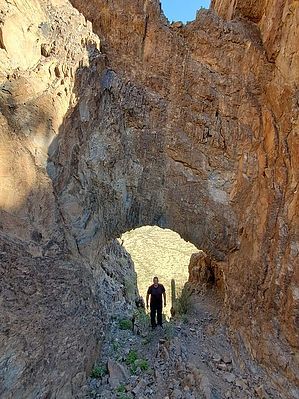
The lost stargate archway by Mike_W  Overview OverviewThe Sawtooth mountains can be seen in the far distance looking West/Northwest from Highway I-10 North of Marana and South of the Picacho exit. It's obvious why these mountains are called the Sawtooths as there are many jagged peaks in the area. This guide describes how to hike to a natural arch/window that exists on Peak 2630, which we learned is also known as Ventana Peak (Window, in English). Hike From the parking area, start out hiking Northwest on the dirt road for about 1/3 of a mile. Next, turn left, going West, and you will cross a wash within a few minutes. After crossing the wash, continue due north for another 0.2 miles, then continue due West for another 0.9 miles. At this point, you should see a road. Take the road Southwest for roughly 0.5 miles. Look for a junction in the road and turn right going West. This junction is at (32.615937, -111.700729). Follow this road for approximately 0.8 miles until there is a Y-split. From this point, do not take either direction, but instead, bushwhack West but slightly North for 0.9 more miles to the low saddle on Peak 2630 / Ventana Peak.
If you are not comfortable with technical rock climbing, there is an easier route going around the rocks on the West side of the mountain to get to the natural arch. On the South side of the arch, more arrows are heading above it. After climbing up there we decided it was too dangerous to proceed over the arch without ropes or better gear. The rock was steep and there weren't many good places to step/hold onto. We decided to return down to the natural arch. From this point, there was a chute sloping West, which was possible to take about 100 feet down, turn to the North and access a ridge that headed up to the peak. One of the hikers in our group (Brian W.) made it to the top of the peak which was a great accomplishment. But, this guide will simply describe how to get to the natural arch/window, which is the most interesting and unique feature of this area. Area Interest Corona Satellite Calibration Targets 2209 Indian Head 2533 Wildcat Peak
Check out the Official Route and Triplogs. Leave No Trace and +Add a Triplog after your hike to support this local community. | ||||||||||||||||||||||||||||||||||||||||||||||||||||||||||||||||||||||||||||||||||||||||