Route Editor

| Guide | ♦ | 3 Triplogs | 0 Topics |
details | drive | no permit | forecast | route |
stats |
photos | triplogs | topics | location |
| 86 | 3 | 0 |
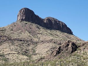
Little Picacho isn't so little by Mike_W  Overview OverviewThe Sawtooth mountains can be seen in the far distance looking West/Northwest from Highway I-10 North of Marana and South of the Picacho exit. It's obvious why these mountains are called the Sawtooths as there are many jagged peaks in the area. This guide describes how to hike to Peak 2614 also known as "Little Picacho". Warning The hike has bushwhacking, and climbing on steep terrain with a lot of gravel and teddy-bear cholla. We were able to climb it without ropes using 1 of 3 known routes. We found a lot of trash and debris which was probably left by border crossers. Hikers should always be careful. We're not aware of how dangerous it would be to encounter border crossers.
From the parking area, start out hiking Northwest/West on the dirt road for about 1.3 miles. This road is faint in some places. If you get off the road, it's possible to continue in that general direction and the bushwhack is pretty mild overall. After roughly 1.3 miles, you'll reach a road heading South/Southwest. Turn left at this junction and continue for another 0.1 miles. At this point, you'll see a road going West. Follow this road for about 0.9 miles until you see a Y-junction. At this Y-junction make a left and follow it for another 0.85 miles until you see another Y-junction. At this Y-junction, make a right and follow the road. The road will continue West for about 0.15 miles and then curve around and go South, Southeast, and then eventually Southwest. After hiking for approximately 4 miles total since the parking area, you should be near the Southeast side of the peak. From here we will bushwhack up to the lowest saddle and then Northwest until reaching the steep rock section. From this point, we stayed at roughly the same elevation and hiked counter-clockwise around the base of the steep rock section. There were white painted arrows in various spots indicating a climbing route... By the way, all around the North side of this rocky area, we found a lot of trash, debris, etc. including 2 car batteries, sleeping bags, blankets, backpacks, articles of clothing, cans, bottles, etc. This is obviously a popular "hideout" spot. Hikers should be careful. Anyway, since this is supposed to be a guide, I will say no more about the trash and the mess we found. Continuing around to the backside (Northwest side) of the rocky area we found a number 2 and arrows going up. From this point, it was possible to climb up to the top of the Western-most peak (lower of the two). There was a lot of gravel here and it was slippery in some areas. There were a lot of cholla cacti that we needed to hike around. When we got to the top, we found a registry with roughly 5 names in the last 5 years. Looking Southeast we saw the top of "Little Picacho" within a few hundred feet from where we were standing. It looked difficult from this angle and I wasn't sure if it was safe to continue. We decided to take it step-by-step and proceed up to the high point. It turned out it was an easier climb than the first and lower peak. It probably took us 15 minutes to get to the top. Again we found a registry and signed in, and we were surprised at how few names were listed here. Maybe only 5 names in the last 5 years. Enjoy the amazing views from up here! Getting down wasn't so easy. We had to take it slow because of the gravel and chollas. The most difficult downhill portion was from the lower peak to the base of the rocky section. Once at the base, we hike West and Southwest until we found a safe route down to the ground level. From here, we followed a faint animal trail out to a road. We followed this trail for approximately 0.5 miles until we hit the road. From here we followed the road back to the starting point. Notes 1. It is possible to drive in further with a 4 wheel drive vehicle, but we decided to park in an area that we've parked at before and we're familiar with. This makes the hike a bit longer than it could be, but we were OK with that. 2. Special thanks to Ken S. who appears to be the person who placed the registries and has done numerous summits in the area. We'll probably hike a few more of these peaks in the coming years. 3. We saw a lot of evidence of trash and debris left from border crossers. We do not know how long this debris was here. We do not know how safe it would be to encounter any of these border crossers, but we could imagine it could be dangerous. On the other hand, we have not heard any stories of problems with encounters. Perhaps it is because there's a very low number of hikers in this area.
Check out the Official Route and Triplogs. Leave No Trace and +Add a Triplog after your hike to support this local community. | ||||||||||||||||||||||||||||||||||||||||||||||||||||||||||||||||||||||||||||||||||||||||