username
X
password
register
for free!
help
 

East Cactus Plain Ramble, AZ

Guide 1 Triplog  0 Topics
  3.5 of 5  
Fav
Wish
0
details
drive
no permit
forecast
route  
stats
photos
triplog
topics
location
9 1 0
Statistics
tap row or icons for details
Difficulty 1 of 5
Route Finding 3 of 5
Distance Loop 10 miles
Trailhead Elevation 1,223 feet
Elevation Gain 150 feet
Accumulated Gain 354 feet
Avg Time Round Trip 4 hours
Kokopelli Seeds 11.77
 Interest Off-Trail Hiking
 Backpack Possible - Not Popular
feature photo
Photos Viewed All MineFollowing
Inaugural Calculation on Button Tap!
9  2022-03-05 GrangerGuy
Author
author avatar Guides 34
Routes 138
Photos 931
Trips 111 map ( 1,347 miles )
Age 68 Male Gender
Location Phoenix, AZ
Associated Areas
list map done
Southwest Region
Historical Weather
Trailhead Forecast
Radar Map
Expand Map
Preferred Nov, Jan, Feb, Mar → 7 AM
Seasons   Late Autumn to Early Spring
Sun  6:11am - 6:58pm
Official Route
 
1 Alternative


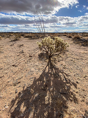
Like Alice, you can fall down the rabbit hole
by GrangerGuy

Overview
The East Cactus Plain Wilderness is the part of the East Cactus Plain east and north of the CAP canal. It has a very unusual crescent dune topography, but the dunes are never more than about 10 feet high. It can be explored for an hour or a day. Likely you won’t see anyone else here.


Hike
There are no trails in this wilderness and few animal paths. Travel in any direction, on any route, is equally easy. The official route is a 10-mile triangle, but you could pick your route. You can’t get lost here.
remove free decal offer
The route starts at the parking area and information kiosk at the south corner of the wilderness. It heads initially north, about 345°, toward Planet Peak, about 10 miles away. Planet Peak makes a good marker to keep you going in the same direction.

After about 4.5 miles, the route makes a sharp right turn and heads straight toward Harcuvar Peak, about 20 miles away. Take this bearing, at about 120°, for 2.5 miles. Then close the loop by hiking straight back toward your car, at about 200°.

Warning
The entire wilderness is covered with rabbit warrens. These are sufficiently close to the surface that breaking through the top as you walk is a common experience. Usually, you will bottom out with a jolt no more than a foot down, but sometimes you may go in past your knees. It is reminiscent of hiking over snow bridges in the spring in the mountains, except you don’t get wet when you fall in. The rabbits' nest on the top of the dunes, so you need to pay attention as you cross each one, and hiking along the tops of the dunes is a really bad idea. Most of the dens seemed to be abandoned.

Other dens are probably occupied by coyotes. There is evidence this place has been coyote restaurant.

2022-03-06 GrangerGuy


    Check out the Official Route and Triplog.
    Leave No Trace and +Add a Triplog after your hike to support this local community.
    WARNING! Hiking and outdoor related sports can be dangerous. Be responsible and prepare for the trip. Study the area you are entering and plan accordingly. Dress for the current and unexpected weather changes. Take plenty of water. Never go alone. Make an itinerary with your plan(s), route(s), destination(s) and expected return time. Give your itinerary to trusted family and/or friends.

     Permit $$
    None


     Directions
    or
     Road
    FR / Dirt Road / Gravel - Car Okay

    To hike
    From Phoenix, take I-10 west to exit 45, Vicksburg Road, and head north to Vicksburg, where you turn left on AZ-72. Follow AZ-72 to Bouse. From the center of Bouse, take Main Street right over the tracks, then turn left on Rayder Avenue, which becomes Swansea Road and becomes dirt. Follow Swansea Road 7.4 miles to the point where it crosses the CAP canal. Shortly past the canal is a parking area and information kiosk, a good place to leave your car for the explore.
    page created by GrangerGuy on Mar 06 2022 10:18 am
     90+° 8am - 6pm kills
    helpcorrectionissue

    end of page marker