Route Editor

| Guide | ♦ | 6 Triplogs | 0 Topics |
details | drive | permit | forecast | route |
stats |
photos | triplogs | topics | location |
| 71 | 6 | 0 |
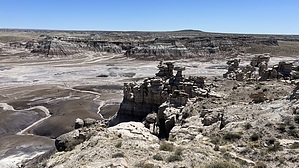
  Overview: Easy hike around the perimeter of Blue Mesa. Overview: Easy hike around the perimeter of Blue Mesa.Hike: Neither the trail nor trailhead are signed. Starting from the southern end of the vehicle pullout, head southeast on a fairly distinct trail. While this hike can be traveled in either direction, the trail is most distinct along the northern half of the mesa, thus making a clockwise loop most logical. As you head generally east, keeping the edge of the mesa on your left, views abound of the purple and white badlands below you. Use caution while standing on the edges to take pictures. The path is loose clay while dry, and a mucky mess if wet. Most of the petrified wood along the path is colorful weathered gravel at this point, but pretty. Larger chunks are scattered around, with the largest pieces visible on the steep hillsides below you. Much of the clay hillsides have weathered into unique-looking hoodoos. If you lose the path, just continue following the edge of the mesa, it is nearly impossible to get lost and your vehicle is visible in the distance most of the time.
Approaching the western end of the mesa, head northwest back towards your vehicle, and you will likely reconnect with the initial trail shortly before reaching the parking area. This is a pleasant, easy hike, with no crowds, and is worth combining with the popular Blue Mesa Loop located just a few hundred feet away.
Check out the Official Route and Triplogs. Leave No Trace and +Add a Triplog after your hike to support this local community. | |||||||||||||||||||||||||||||||||||||||||||||||||||||||||||||||||||||||||||||||||||||||