 Route Editor

| Guide | ♦ | 3 Triplogs | 0 Topics |
details | drive | no permit | forecast | 🔥 route |
stats |
photos | triplogs | topics | location |
| 16 | 3 | 0 |
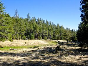
sallows and osiers rejoice by kingsnake   Overview: The head of Willow Creek is between Promontory Lookout and Carr Lake, on the Mogollon Rim. Willow Creek heads north past the Rancho Allegro site, through Bennet Butler Ranch, over Pauls Crossing at FR 84, until seven miles later it empties into Bear Canyon at Mule Crossing on FR 89. Note: Willow Creek is not the same as Willow Springs Canyon, which is 7½ miles southeast. Overview: The head of Willow Creek is between Promontory Lookout and Carr Lake, on the Mogollon Rim. Willow Creek heads north past the Rancho Allegro site, through Bennet Butler Ranch, over Pauls Crossing at FR 84, until seven miles later it empties into Bear Canyon at Mule Crossing on FR 89. Note: Willow Creek is not the same as Willow Springs Canyon, which is 7½ miles southeast.From FR 34 / Wallace Rd., FR 9443 descends 50 rocky feet to a trail split. Go right. Just over a mile into the hike, there was a log blocking the road, but it is sawed through, and in any case, routed around. That is where you drop 120 steep, but mostly obstacle-free, feet down to Willow Creek.
A mile north, the jeep trail splits: Left to stay on FR 9419A, right for a short loop (4.2 mi., 290 AEG) out of the canyon, back on FR 9443. A ¼ mile past the split, FR 9419A peters out. There are also bail points / shorter loop options at the power line (7.2 mi., 430 AEG) and a foot trail up to Ives Mesa Tank (8.5 mi., 490 AEG). After the FR 9419A split, the next 2½ miles north has some rocky spots and minor deadfall, but plenty of shelves, so the travel never gets difficult. There are fewer, smaller, pools. The canyon never gets too deep, nor too steep. Certainly no cliffs. After hiking 4¾ miles this hike reaches Paul's Crossing. Turn east, uphill, on FR 84. After 300 yds., FR 9443 is on the right. There are downfall roadblocks all along FR 9443. Easily avoided by humans, not so much by vehicles. FR 9443 winds south four often rocky miles back to the drop-in point, and five to the trailhead. FR 9443 is generally mid-slope above Willow Creek: It never gets more than 100 yds. away, and 80 ft. upslope, of the canyon bottom. So, if you are not near one of the bail points I mentioned earlier, bailing would never be too difficult. Gate Policy: If a gate is closed upon arrival, leave it closed after you go through. If it is open, leave it open. Leaving a closed gate open may put cattle in danger. Closing an open gate may cut them off from water. Please be respectful, leave gates as found. The exception is signage on the gate directing you otherwise. Check out the Official Route and Triplogs. Leave No Trace and +Add a Triplog after your hike to support this local community. One-Way Notice This hike is listed as One-Way. When hiking several trails on a single "hike", log it with a generic name that describes the hike. Then link the trails traveled, check out the example. | ||||||||||||||||||||||||||||||||||||||||||||||||||||||||||||||||||||||||||||||||||||


