 Route Editor

| Guide | ♦ | 40 Triplogs | 1 Topic |
details | drive | no permit | forecast | 🔥 route |
stats |
photos | triplogs | topic | location |
| 318 | 40 | 1 |
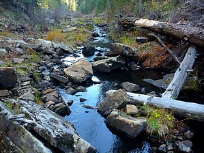
Tale of Two Willows by chumley  How many Willow Springs Canyons are there in Arizona? More than two! This hike describes the one that begins at Willow Springs Lake, at an elevation of 7500 feet on top of the Mogollon Rim. How many Willow Springs Canyons are there in Arizona? More than two! This hike describes the one that begins at Willow Springs Lake, at an elevation of 7500 feet on top of the Mogollon Rim.Overview Willow Springs Canyon is an off-trail hike heading 4-miles down an ever-narrowing canyon beginning at the Willow Springs Lake dam to the canyon's very remote confluence with Woods Canyon and Chevelon Canyon.
This hike is listed one-way! Returning the way you came will double the mileage indicated, to a total of 8 miles traveled. Other options are available, as indicated at the end of this description. Hike Begin at the Willow Springs Lake boat ramp, and head north toward the dam. Follow the fence's left side along the spillway and follow it down to the dam's backside. You've already gone half a mile! This is by far the steepest terrain you will encounter all day! Enjoy the stroll in the grassy meadows alongside the trickling stream. Follow the existing use-trails or old roadbed that parallels the drainage. This relaxing part of the hike meanders for nearly 1.5 miles before the meadow closes in, and the trickling grassy creek enters a forested area and turns into more of a rocky mountain stream. Ideally, you will want to be on the right side (east) of the creek, so as you meander down the meadows above, make sure to find your way to the right bank at some point. Not that it is challenging to cross once you enter the more wooded lower section of the canyon. Caution If you are not an experienced off-trail hiker, I don't recommend proceeding down canyon beyond the grassy meadows and the 1.5-mile distance. It gets progressively more difficult and more remote the farther you go. Make sure to turn around if you no longer feel comfortable with the terrain. Once in the canyon's wooded section, the use trails peter out, and you will find yourself doing more exploring and bush-whacking. Initially, the canyon is wide and shallow, and there's plenty of room on the banks for hiking. However, soon, you will find that travel is best done via rock-hopping down the stream's center. The canyon narrows and the banks' vegetation becomes thicker and less-pleasant to attempt to get through. There are occasional pools, but none much more than knee-deep. The entire hike can be done without getting your feet wet, but a couple of places where a little creativity may be needed to accomplish that goal. As you descend the gentle slope farther into the canyon, the mountain stream's sound you are walking in soothes the ears. The increasing remoteness raises the possibility of wildlife sightings. I encountered a giant, fat porcupine on a rock right in the middle of the stream. Unlike many wildlife sightings, he was not just a shadow running away, but rather, a slow, lazy, wobbly blob that I had to encourage to get out of my way! About 3.75 miles into your hike, the most unpleasant of things happen! The stream you are walking in disappears. Vanished. Nothing but dry rocks, sand, and boulders in a 500-foot deep canyon. You can proceed the last few hundred yards to the junction of Woods Canyon and Chevelon Canyon. There is ample flat ground, and pine and willow shaded forest at the intersection for lunch or camping. From here, turn around and hike the 4-miles back upstream to the lake. Water Flow Note This description was written based on a pre-monsoon June 30 hike. During spring snowmelt or monsoon runoff, water may exist in the canyon below this point. It does appear that the stream up to this point is perennial and fed by multiple unseen seeps/springs along the way. 2012 has been an arid year, and there was ample clear water flowing nicely in the stream the entire way up to just before the junction where the water disappeared. Only the significantly lower portion of this canyon hike appears to be susceptible to dangerous flooding potential. But be aware of surrounding terrain, water flow, and weather if you visit during the summer monsoon. Backpacking Options Backpackers might continue down Chevelon Canyon another ~10-miles to the first established canyon exit point at the Telephone Ridge Trail #203, or the full 13-miles to the head of Chevelon Canyon Lake where another exit trail exists. Or they might head up Woods Canyon for the 6-miles to the Woods Canyon Lake dam. Except for the three canyons' junction, the only good camping opportunities in Willow Springs Canyon were in the grassy meadow section in the first 1.5 miles from the lake. Check out the Official Route and Triplogs. Leave No Trace and +Add a Triplog after your hike to support this local community. One-Way Notice This hike is listed as One-Way. When hiking several trails on a single "hike", log it with a generic name that describes the hike. Then link the trails traveled, check out the example. | |||||||||||||||||||||||||||||||||||||||||||||||||||||||||||||||||||||||||||||||||||||||||||||||||||||||||||||||||||||||||||||||||||||||||||||||||||||||||||||||||||||||||||||||||||||||||||||||||


