Route Editor

| Guide | ♦ | 8 Triplogs | 1 Topic |
details | drive | permit | forecast | route |
stats |
photos | triplogs | topic | location |
| 142 | 8 | 1 |
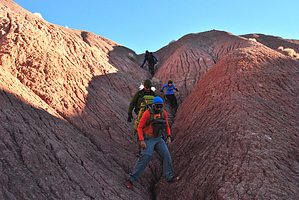
The top of PeFo by rally_toad   A journey to the top of Pilot Rock is a real adventure. Off-trail the entire way through what can be harsh and rugged territory. The lack of water means that all water must be packed in, which can make for quite a heavy pack. However, the reward is worth it, as only a handful of people climb Pilot Rock and most of them are park employees. Chances are you will not see anyone from the time you leave Kachina Point until you arrive back at the trailhead. A journey to the top of Pilot Rock is a real adventure. Off-trail the entire way through what can be harsh and rugged territory. The lack of water means that all water must be packed in, which can make for quite a heavy pack. However, the reward is worth it, as only a handful of people climb Pilot Rock and most of them are park employees. Chances are you will not see anyone from the time you leave Kachina Point until you arrive back at the trailhead.This could be done either as a backpack or a long dayhike. There are plenty of places to tent camp on flat ground. However there are no trees, so no hammocking (sorry te-wa!).
So what is the other way? Consult a topographical map and you will see it right away. The land east of Pilot Rock is much gentler and more easily navigated. So the 2nd way would be to hike north from Kachina Point until you are east of Pilot and tackle it from the east. This is the way I was able to summit Pilot. However, this way is still not easy and will take effort. There are other cool things to say out in the Wilderness area of Petrified Forest, petroglyphs, Indian ruins, an old model-t, pottery sherds, petrified wood, and Onyx Bridge. This Wilderness is relatively pristine and probably my favorite place in the park. It is a great way to get away from the crowds along the roads and short trails at PeFo and see something that 99% of visitors do not see. It's unlikely that the same route will be taken twice, so the mileage and elevation gain is a general, rough estimate. Stay safe and have fun!
Check out the Official Route and Triplogs. Note This is a difficult hike. It would be insane to attempt this entire hike without prior experience hiking. Leave No Trace and +Add a Triplog after your hike to support this local community. | |||||||||||||||||||||||||||||||||||||||||||||||||||||||||||||||||||||||||||||||||||||||||||||||||||||||||||||||||||||||||||||||||||||||||||||||||||||||||||||||||||||