Route Editor

| Guide | ♦ | 46 Triplogs | 0 Topics |
details | drive | permit | forecast | route |
stats |
photos | triplogs | topics | location |
| 467 | 46 | 0 |
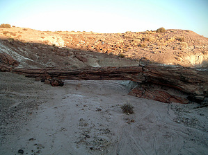
Hot, dry, and beautiful. by PaleoRob   Onyx Bridge is an ancient petrified log laying across an arroyo, forming a natural bridge. Pretty cool stuff! It's similar to Jasper Bridge, further south in Petrified Forest National Park, but without the trails, tourists, or concrete buttresses. Onyx Bridge is located in one of the least-accessed wilderness areas in the state - the Black Forest Wilderness, in the northern reaches of Petrified Forest National Park. Onyx Bridge is an ancient petrified log laying across an arroyo, forming a natural bridge. Pretty cool stuff! It's similar to Jasper Bridge, further south in Petrified Forest National Park, but without the trails, tourists, or concrete buttresses. Onyx Bridge is located in one of the least-accessed wilderness areas in the state - the Black Forest Wilderness, in the northern reaches of Petrified Forest National Park.The Black Forest Wilderness is a huge area, sweeping northward from Lithodendron Wash to the park's boundary with the Navajo Reservation. It's a land full of sweeping Chinle hills, slick as ball-bearings when dry, thigh-deep mud when wet (which isn't very often). In the whole of this huge expanse, there are maybe a handful of places to get water - half of them unreliable. Yet everywhere giant stone logs and petrified bones attest to a wetter climate. Petroglyphs and some rudimentary ruins dot the landscape - a landscape full of exploration potential.
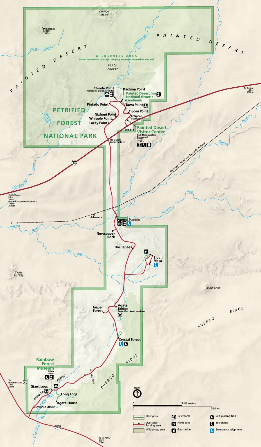
The trail starts at the Painted Desert Inn (now a museum undergoing some restoration). Before leaving there, stop at the visitor center at the entrance station and request a map to Onyx Bridge. It's hand-drawn, but its landmarks are very useful. The trail passes a "wilderness ethics" sign and quickly drops off the mesa in a series of sharp switchbacks. The only shade on the route down (and therefore the route up) is a lone juniper at one bend in the trail. To make matters more difficult, the mesa is an old lava flow - black basalt. In the summer, this escarpment can be torture. Finally, however, the trail reaches some of the underlying Chinle, and from there to Lithodendron Wash, the going is mostly flat. Not, however, straight. For all its faults, the switchbacks were at least well defined. After leaving the Chinle-formed wash and entering onto the Lithodendron floodplain, the trail slowly disintegrates. Don't lose heart. Look back at the mesa and memorize its features. There are dozens of red-sloped washes along the base of the mesa, but only one leads to the switchbacks. With that image in your mind (or coords in your GPS), strikeout heading north. As long as you head north towards the bluffs on the horizon, you're going in the right direction. As you walk north across the plain, you'll notice that you're paralleling a spur to the west. If you want to take a rest stop and check out some petroglyphs, check out the prominence where the spur ends at Lithodendron Wash - there are several boulders covered with petroglyphs there. Finally, Lithodendron Wash. The major "watercourse" in the BFW is almost always dry. In my half dozen visits in the last four years, there's never been any water, not even a pothole in the streambed. Bad news for resupply, good news for you, because the bed of Lithodendron Wash represents the easiest way to get to Oynx Bridge. Follow the wash upstream (to the east). Lithodendron Wash continues east for about a quarter-mile (depending on where you intersect it) and then turns abruptly to the north, following the red and blue mudstone cliffs now to the west (part of the same series of bluffs seen from the approach from the south). Keep in the wash for about another half mile, until coming to a wide, "grassy" area. It's easy to tell when you're there - it's the most vegetated area since dropping off the mesa almost two miles back. There's an embayment on the side of the bluffs at a westward bend in the wash, with a couple of small drainages coming out of it. They look steep, but either of them will take you to the top of the bluff with some careful scrambling. Stop. Take a look around. You should be able to pick out the mesa to the south, but the Painted Desert Inn may be difficult to find along its profile. To the west, if the weather's clear and you're on a high-enough mound, the San Francisco Peaks should be visible. All around you stretches the red, brown, yellow, white, blue, and grey clay hills of the Chinle formation, laid down over 200 million years ago. Fossilized tree trunks dot the landscape, some as big as a man and twice as tall. In some places the prehistoric debris is so thick it forms natural staircases up gullies to the top of mesas. Head north, northeast along the cliff line until you reach Onyx Bridge - it's in a drainage that leads back down to Lithodendron Wash. The exact coords for the Bridge are: 35 06' 40"N, 109 47' 20"W if you can't locate it by looking - and it can be pretty hard to find even with that information, so good luck. The Black Forest is an amazing place, and frankly almost unvisited (save for a few hardy dayhikers headed for the Bridge) - if you don't mind bringing water, it makes an excellent place for an overnight backpack trip. The scenery is just striking, there are no two ways to put it, and there's so much history in the area, it's just impossible to not look down at the ground and not see something ancient, usually something much older than humans! If you're backpacking, remember that almost everything south of Lithodendron Wash is not part of the Black Forest Wilderness; you've got to cross the wash before setting up camp. If you plan on spending the night, be aware that no water in the wilderness is reliable - bring lots. The park recommends a gallon per person per day, more sometimes in the summer - it's hot and there's no shade. The park locks down at closing time, so make sure you've got everything you need because you're locked in for the night. To backpack, you need a free permit from the visitor center at the entrance station, and it must be obtained at least one hour before park closing. Horse trips are allowed, no permits are required for day trips, but you must bring all the feed required. Contact the park for information on overnight horseback trips at (928) 524-6228. Remember, as always, don't take anything home that you find out there, save for your photos and memories. One of the main reasons this place has had such an impact on me is the sheer volume of stuff out there - hopefully you'll be equally awed and want to leave it just the way you found it.
Check out the Official Route and Triplogs. Leave No Trace and +Add a Triplog after your hike to support this local community. | ||||||||||||||||||||||||||||||||||||||||||||||||||||||||||||||||||||||||||||||||||||||||||||||||||||||||||||||||||||||||||||||||||||||||||||||||||||||||||||||||||||||||||||||||||||