Route Editor

| Guide | ♦ | 4 Triplogs | 0 Topics |
details | drive | no permit | forecast | 🔥 route |
stats |
photos | triplogs | topics | location |
| 18 | 4 | 0 |
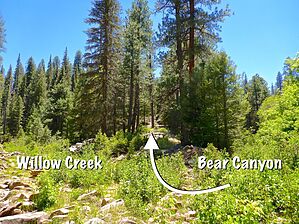
Not THAT one: THIS one. by kingsnake   Overview: Bear Canyon is located atop the Mogollon Rim, just a ½ mile directly north of Christopher Creek and See Canyon Trail #184. Bear Beaver Ridge is on its west flank; Bear Willow Ridge to the east. (On the Rim, ridges tend to be named after the two canyons which border them.) Bear Canyon is dammed two miles north of Rim Road / FR 300, forming Bear Canyon Lake. This hike heads from the dam, north to Mule Crossing, at the confluence with Willow Creek, then double backs along forest roads. Overview: Bear Canyon is located atop the Mogollon Rim, just a ½ mile directly north of Christopher Creek and See Canyon Trail #184. Bear Beaver Ridge is on its west flank; Bear Willow Ridge to the east. (On the Rim, ridges tend to be named after the two canyons which border them.) Bear Canyon is dammed two miles north of Rim Road / FR 300, forming Bear Canyon Lake. This hike heads from the dam, north to Mule Crossing, at the confluence with Willow Creek, then double backs along forest roads.This Bear Canyon is different than the other Bear Canyon, which is 12 miles west, also atop the Mogollon Rim. Not sure why there is more than one. Maybe because the other Bear Canyon is in the Coconino National Forest, and this one is in the Apache-Sitgreaves National Forest. And has a lake.
The canyon's bottom has water for about a mile north of the dam. Some pools, some more creek-like. One to six feet wide; up to 6" deep. But no flow. The canyon bottom was dry the next two miles. The final mile to Mule Crossing had pools again -- one was 20 ft. x 50 ft. and a good 18" deep -- with some light trickle. The first watery stretch of Bear Canyon ends just south of the log jam. The jam was so large, that it reminded me of North Woods timber rafts. Trying to walk across the log jam is a sure leg breaker, but it is easily avoided. There are several unusual objects in the canyon: The first, a ½ mile north of the dam, on the east shelf, was what I thought at first was a booby trap made of short, staked, logs. Not sure though. Also, in a clearing ¾ mile south of Mule Crossing, I found a lean-to. There are several possible bail points. I marked one, a ½ mile north of the powerline, which has an animal trail west, up a spur. That option is 2.0 miles, 300 AEG, back to the trailhead via FR 89A3. Oregon_Hiker bailed east to FR 84B, near that point. That option is 3.0 miles, 400 AEG, back to the trailhead. The middle two miles of the canyon are often rocky. Though still hikeable, take what shelves are available, and there are plenty. You should never stray more than 20 ft. upslope. When you reach FR 89 at Mule Crossing, turn back and look at the way you came. Willow Creek will be to your left; Bear Canyon to your right. Head up the spur between them. It is a 180 ft. climb in a mostly brush-free ⅒ mile. FR 84B, at the top of the climb, is the halfway point of the hike. Simply follow it south, back under the power line (where it becomes FR 92A1), for 4¼ miles to the locked heavy gate. Go through the gate, down FR 84A, to the dam, then back up to the trailhead. Gate Policy: If a gate is closed upon arrival, leave it closed after you go through. If it is open, leave it open. Leaving a closed gate open may put cattle in danger. Closing an open gate may cut them off from water. Please be respectful, leave gates as found. The exception is signage on the gate directing you otherwise. Check out the Official Route and Triplogs. Leave No Trace and +Add a Triplog after your hike to support this local community. | ||||||||||||||||||||||||||||||||||||||||||||||||||||||||||||||||||||||||||||||||||||