 Route Editor

| Guide | ♦ | 3 Triplogs | 0 Topics |
details | drive | permit | forecast | route |
stats |
photos | triplogs | topics | location |
| 0 | 3 | 0 |
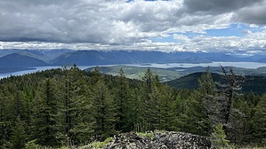
Golden views by LindaAnn Hike: While there is no official trail up to the summit of Gold Hill, several dirt bike paths make for a fairly easy hike to the top. The route posted is just one of the options, and there is another path that starts a little farther to the east, at the end of the road, which would have almost the same distance and gain.
Continue following this path uphill as it winds west, then south again. As the path approaches the summit, the trees give way, and the summit has open views in nearly all directions. There is a large cairn at the highpoint. The views to the northeast of Lake Pend Oreille and the Cabinet Mountains are particularly impressive. After enjoying the expansive views, make your way back downhill to your starting point. Note: Rather than driving the forest road up, this hike can also be combined with Gold Hill Trail #3 for a roughly 8.50-mile roundtrip hike. Check out the Official Route and Triplogs. Leave No Trace and +Add a Triplog after your hike to support this local community. One-Way Notice This hike is listed as One-Way. When hiking several trails on a single "hike", log it with a generic name that describes the hike. Then link the trails traveled, check out the example. | ||||||||||||||||||||||||||||||||||||||||||||||||||||||||||||||||||||||||||||


