 Route Editor

| Guide | ♦ | 2 Triplogs | 0 Topics |
details | drive | no permit | forecast | route |
stats |
photos | triplogs | topics | location |
| 0 | 2 | 0 |
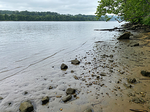
Stone walls and a tidal estuary by GrangerGuy Hurd State Park has several hiking trails, imaginatively named Green, Red, Orange, etc. The Red Trail meanders from CT-151 through the park and intersects every other trail at some point. Hike The route starts at the parking lot at the intersection of CT-151 and Hurd Park Road. This lot is open year-round. The path starts at the southeast corner of the lot and is on a section of the Green Trail coincident with the White Trail for a short distance until the White Trail bears off to the right. Stay on the Green Trail, and after about 0.2 mi, the Red Trail officially begins on the right.
One mile from the parking lot, the trail intersects a dirt park road, which is a one-way loop with parking areas. Turn right and follow the road. When the parking loop bears left, continue straight through a gate on a closed two-track. In about 100 yards from the gate, at a poorly marked junction, the two-track bears left, marked Red Trail bears right. In a little while, the Connecticut River comes into view and the trail begins dropping to the river, where it comes out at a small beach. The river is tidal here, so be careful not to slip on the rocks at low tide. The trail follows along at river level for a while and comes first to one meadow, then to a second. The second meadow contains an outhouse, fire pits, and a picnic table. It is used for overnight camping for river travelers only. The trail climbs up the bank just as you enter the second meadow. As it continues to climb, it intersects with the Orange Trail to Split Rock. From the terrestrial side, Split Rock is a great viewpoint. From the riverside, it is an important landmark. Continuing, the Red Trail intersects both ends of the Yellow Trail loop and then encounters the main park road, paved here. Jog right a short distance on the paved road, and the Red Trail veers off to the left, where it begins to follow an old, paved road. The Red Trail climbs along this old road, passing one end of the Blue Trail, and finally arriving at the main picnic area with a large lawn, pavilion, and outhouse. A hand-operated water pump is there, but the handle is missing. From the picnic area, if you are making a loop with the Green Trail, follow the trail out the back of the lawn behind the pavilion, generally heading northwest. Gate Policy: If a gate is closed upon arrival, leave it closed after you go through. If it is open, leave it open. Leaving a closed gate open may put cattle in danger. Closing an open gate may cut them off from water. Please be respectful, leave gates as found. The exception is signage on the gate directing you otherwise.
Check out the Official Route and Triplogs. Leave No Trace and +Add a Triplog after your hike to support this local community. One-Way Notice This hike is listed as One-Way. When hiking several trails on a single "hike", log it with a generic name that describes the hike. Then link the trails traveled, check out the example. | |||||||||||||||||||||||||||||||||||||||||||||||||||||||||||||||||||||||||||||||||||||||||


