 Route Editor

| Guide | ♦ | 5 Triplogs | 0 Topics |
details | drive | no permit | forecast | route |
stats |
photos | triplogs | topics | location |
| 24 | 5 | 0 |
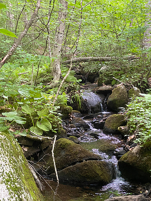
A mix of serenity, roads, and bushwhacking by GrangerGuy  The Shenipsit Trail runs from East Hampton, CT to Stafford, a distance of about 45 miles. It is divided into 3 main sections, south, central, and north. The central section, described here, follows wooded trails through a deciduous forest. It runs from Vernon south to Glastonbury. Several trail sections are separated by road walking sections, or you can skip the roads and just do the trail sections. The southernmost part is in Meshomasic State Forest, the oldest state forest in New England. Much of the rest is on easements on private or conservation land. Hike The trail is described from north to south. From the Walker Reservoir parking lot, walk a few yards west on Reservoir Road. At the curve in the road, the trail ducks off to the north. The trail follows counterclockwise around Walker Reservoir West, along the I-84 fenceline for a bit, and descends through open forest to Baker Road. Follow a ravine through mixed oak, birch and hemlock down to a bridge across the Tankerhoosen River.
Cross the dam at the outlet to the pond and follow along the pond for a short way and then the trail turns right and climbs the hill sharply up to a nice viewpoint and the intersection with the Hop River State Park Trail, a rails-to-trails project. The Shenipsit is coincident with the Hop River Trail almost all the way to Bolton Notch Pond. It is all uphill, but very gentle. Just before the Pond, the Shenipsit leaves the Hop River, crossing Railroad Brook, and climbs up to nice views over the waterlily-choked pond. It passes through Bolton’s Freja Park and comes out at the Bolton Park-and-Ride. Getting to the next segment of the forest trail requires a walk on a bike path that leaves out of the east side of the lot. Follow the bike path on a bridge up over the westbound lanes of US-44, alongside I-384, and under the eastbound lanes of US-44. Follow the bike path about 5/8 mile along I-384, and then cross the freeway on Bolton Center Road. Continue a couple hundred yards to the trail on the right. Look for the blue blaze paint on the street; it is easy to miss. Thus begins the most poorly maintained section of the trail (as of 2022). The trail is overgrown, blazes are sparse, and at least at one point, it is 50 yards of total bushwhack to find where the trail goes. At another point, the trail just blows by a No-Trespassing sign. This apparently does not mean you if you are hiking the trail. Nevertheless, thanks to the Connecticut Forest and Park Association for all they do to maintain the blue-blazed trail system. Keep your wits about you and have the route loaded on your GPS. After crossing Birch Mountain Road, the trail enters Case Mountain Park, and from here to the next parking on Birch Mountain Road in Glastonbury, the trail is in beautiful shape. Case Mountain Park is quite nice. There is a white-blazed carriage road that goes to the summit of Birch Mountain. The Shenipsit Trail crosses it several times. From the summit of Birch Mountain, the trail goes through many gentle ups and downs, eventually coming to a power line. Note that the blue-blazed trail takes a left turn just before the powerline clearing. It follows along the clearing for a short distance before heading straight across the power lines. Shortly thereafter, the trail emerges by the parking at Birch Mountain Road. Hike a quarter mile south on Birch Mountain Road to CT-94, go right a hundred yards, and pick up the southbound trail there on an easement between 3314 and 3338 Hebron Ave. Leaving the lawn, the trail dives into the woods and follows along an algae-covered pond. In a short distance, it comes out on Pheasant Crossing. Just past the second house on the right, there are blue blazes on a white box pointing between the houses, through a little orchard, and back into the woods. The trail descends along the back boundary of several homes. At 0.8 mi from CT-94, cross Diamond Lake Road. There is no obvious parking here. Turn right, and in about 100 yards, the trail turns left off the road just before a cable guardrail. Continue south past another pond, and cross Imperial Drive. Drop steeply down to a freely flowing brook, and then climb back up a little to follow the brook at a respectful distance. At about ¾ mile from Imperial Drive, the trail enters the state forest, leaves the brook, and heads sharply up the hill. In another ¾ mile or so, the trail begins following the ridge line southwest. There are some views from this ridge in the winter. Along the ridge, the trail passes through the Zihrup Open Space Preserve of the Kongscut Land Trust. It is marked “Foot Traffic Only”; in general, the Shenipsit prohibits wheeled vehicles. Shortly after John Tom Hill, the highest point in Glastonbury, at 881’, the trail re-enters the state forest. At about 4 miles from CT-94, you may hear the sounds from the Glastonbury Shooting Range. Then soon after, the sounds of trucks on CT-2. At 5 miles, the trail begins a steep descent off the ridge. Trekking poles are valuable. There are lots of scratches on the rock from people slipping while wearing microspikes. Soon, the trail comes out alongside CT-2. Turn right along the highway, through a field of wood chips, and the blue-blazed trail appears. Following along the highway, near Dark Hollow Brook, there is a green-blazed trail heading down towards the highway. It may be possible to connect with the south section of the Shenipsit Trail using the culvert under the highway, following this trail. The blue blazes continue parallel to the highway and begin following a concrete section of the old New London Turnpike. Pass the shooting range with a toilet, and then at 6.1 miles, arrive at the parking lot at the end of Toll Gate Road. Note This trail is maintained by the Connecticut Forest and Park Association. Check out the Official Route and Triplogs. Leave No Trace and +Add a Triplog after your hike to support this local community. One-Way Notice This hike is listed as One-Way. When hiking several trails on a single "hike", log it with a generic name that describes the hike. Then link the trails traveled, check out the example. | |||||||||||||||||||||||||||||||||||||||||||||||||||||||||||||||||||||||||||||||||||||||||


