Route Editor

| Guide | ♦ | 4 Triplogs | 0 Topics |
details | drive | permit | forecast | route |
stats |
photos | triplogs | topics | location |
| 11 | 4 | 0 |
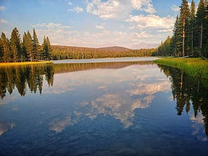
Take a photo for Fido by mikemcg A short trail with a moderate incline that leads to and around a peaceful lake with beautiful views and abundant wildlife. The trailhead is at the north end of the Lembert Dome Picnic Area, a popular spot. It is also the starting point to go to Lembert Dome, Young Lake, and Tuolumne Meadows.
The trail starts flat for about 200 meters, with views of Lembert Dome to the northeast. It then climbs steadily, ascending about 400 feet over a half mile, then flattens briefly before one more short climb. It is well-maintained but rocky in some parts, with tree cover throughout. About 0.8 miles in, there is a side trail that leads to the top of Lembert Dome, which provides excellent views. Approximately 1.1 miles in, there is a fork where the hiker can continue north toward Young Lake (5 miles further) or proceed northeast to Dog Lake. Dog Lake was serene and beautiful, with mountains in the distance. The water was clear and cold. There were multiple deer, and they didn't seem at all concerned about the presence of humans nearby. There were numerous ducks on the lake. The trail encircles the lake, then the same trail can be taken back down to the parking lot. Note No pets permitted!
Check out the Official Route and Triplogs. Leave No Trace and +Add a Triplog after your hike to support this local community. | |||||||||||||||||||||||||||||||||||||||||||||||||||||||||||||||||||||||||||