 Route Editor

| Guide | ♦ | 1 Triplog | 0 Topics |
details | drive | permit | forecast | route |
stats |
photos | triplog | topics | location |
| 14 | 1 | 0 |
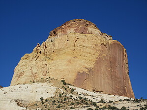
Icon of Capitol Reef by trekkin_gecko  A moderate hike with little shade and a lot of sun exposure to a high point on the Waterpocket Fold with views of the Golden Throne and Capitol Gorge. Geology The Golden Throne towers 7,042 feet. It consists of a golden Navajo Sandstone. The gold is special because normally the sandstone is creamy white or red. Carmel Formation on top of the Navajo Sandstone is the reason for this staining.
Golden Throne Trail begins just west of the Capitol Gorge trailhead. The hike features a steady ascent winding along a few drainages, climbing above Capitol Gorge on the north side. Most of the hike is on slickrock, with good footing. The terrain is similar to the Cassidy Arch hike. The official trail ends at a signpost, with a view of the Golden Throne formation to the northeast. This butte rises another thousand feet above, along with two smaller buttes, all of them a bright yellow color. Beyond the signpost is a nice overlook, worth wandering around for photos, views, and a snack. Return the same way. Synopsis A great sunrise and sunset hike, the throne glows in the deep low-angle light. Nothing overly strenuous on the steady incline along cliff walls. 48-Second Video
Check out the Official Route and Triplog. Leave No Trace and +Add a Triplog after your hike to support this local community. One-Way Notice This hike is listed as One-Way. When hiking several trails on a single "hike", log it with a generic name that describes the hike. Then link the trails traveled, check out the example. | ||||||||||||||||||||||||||||||||||||||||||||||||||||||||||||||||||||||||||||||||||


