Martina Mountain - Roskruge Mountains, AZ | HikeArizona


Martina Mountain - Roskruge Mountains, AZ

Guide 1 Triplog Mine 0 0 Topics
 
2 of 5 
Fav
Wish
0
details
drive
no permit
forecast
route  
stats
photos
triplog
topics
location
23 1 0
Statistics
tap icons for details
Difficulty 3.5 of 5
Route Finding 2 of 5
Distance Lasso-Loop 2.9 miles
Trailhead Elevation 2,810 feet
Elevation Gain 1,219 feet
Accumulated Gain 1,219 feet
Avg Time Round Trip 2.5 hours
Kokopelli Seeds 9
 Interest Off-Trail Hiking & Peak
 Backpack No
unreported if dogs are allowed
editedit > ops > dogs to adjust
feature photo
Photos Viewed All MineFollowing
23  2022-10-25 Mike_W
Author
author avatar Guides 45
Routes 67
Photos 2,584
Trips 215 map ( 1,199 miles )
Age 51 Male Gender
Location Tucson, AZ
Historical Weather
Trailhead Forecast
Radar Map
Expand Map
Preferred Nov, Dec, Jan, Feb → 9 AM
Seasons   Autumn to Early Spring
Sun  6:41am - 6:31pm
Official Route
 
0 Alternative
 
 Water
Nearby Area Water
[ View More! ]
no photo labels yet
+Add > Photos to this Guide
then label as applicable
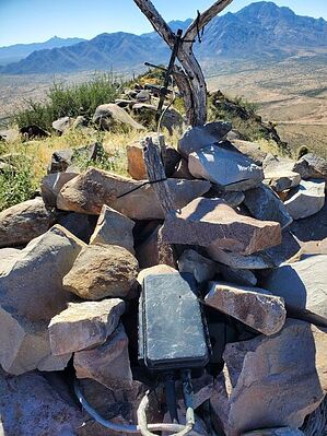
The mine must not have been profitable
by Mike_W

 
Overview
Martina Mountain is on the southern edge of the Roskruge Mountains. This hike involves walking part of a 4x4 road and a scramble up a rocky steep mountain where the rocks can often be loose. There was mining activity here in the past but currently, there isn't any mining activity.
Hike
Park at the road junction North of Martina peak and walk south/southwest down the 4x4 road. The road will turn to the right, then left, and then right again before ending after walking about 1 mile. At the end of this road is a concrete foundation and you'll also see several areas of tailings from the mining activity on the side of the mountain above the road.

From here, the hike is a rock scramble to the top. There are many bad ways to go and a few good ways. It would be best to try to go around the tailing areas where the rocks are more secure and embedded. Be prepared to encounter loose rock on the way up and down regardless of which way you go. Eventually, you will make it to the top.

Once up, you may need to walk on top of or slightly below the ridgeline to the high point that is near the south end of the ridge. At the high point, you will see a solar panel, a small antenna, and a registry covered by a few rocks. Carefully return down the rocky channel on the north side of the mountain to the road and back down the road to your parking area.

Check out the Official Route and Triplog.

Leave No Trace and +Add a Triplog after your hike to support this local community.

2022-10-26 Mike_W
    WARNING! Hiking and outdoor related sports can be dangerous. Be responsible and prepare for the trip. Study the area you are entering and plan accordingly. Dress for the current and unexpected weather changes. Take plenty of water. Never go alone. Make an itinerary with your plan(s), route(s), destination(s) and expected return time. Give your itinerary to trusted family and/or friends.

     Permit $$
    None


     Directions
    or
    or
     Road
    Strictly 4x4

    To hike
    Take Rt 86 (Ajo Way) West of Tucson and pass through the town of Three Points. After passing Sasabe Road (Rt 286), you'll continue on Ajo Way for roughly 4 miles. Then, look for the sign marking the Tohono O'Odham Indian reservation. You'll make a right turn just before this sign, and enter State Trust Land.

    There will be a gate here right by the road. If you find a gate closed, always close it again after passing through. Continue for about 1.1 miles and then look for a faint left. This turn can be easy to miss and there is a ditch shortly after turning that will only be possible with a 4x4 and high clearance. You'll continue through 2 gates in a relatively short period of time. The road will get pretty rocky at times.

    After traveling a total of 2.6 miles, look for your next left. This road will continue for another mile until it ends. I chose to park near the road junction and walk the roughly 1 mile of 4x4 road because it got quite rugged and steep after this turn.
    page created by Mike_W on Oct 26 2022 1:08 am
    helpcorrectionissue

    end of page marker