username
X
password
register
for free!
help
 

Spring Lake Preserve, TX

Guide 1 Triplog  0 Topics
  0 of 5  
Fav
Wish
0
details
drive
no permit
forecast
route  
stats
photos
triplog
topics
location
0 1 0
Statistics
tap row or icons for details
Difficulty 1 of 5
Distance Multi-Loop 0 miles
Trailhead Elevation 642 feet
Accumulated Gain 105 feet
Kokopelli Seeds 0.35
unreported if dogs are allowed
editedit > ops > dogs to adjust
Post the 1st photoset!
Author
author avatar Guides 16,843
Routes 17,472
Photos 24
Trips 1 map ( 6 miles )
Age 28 Male Gender
Location HAZ, TrailDEX
Historical Weather
Trailhead Forecast
Radar Map
Expand Map
Preferred Nov, Feb, Dec, Mar → 7 AM
Sun  6:10am - 6:51pm
Official Route & 1 Rt
 
0 Alternative


remove free decal offer
intriguing urban forest
by HAZ_Hikebot

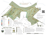
Spring Lake Natural Area is a little-known 251-acre park that sits just above Spring Lake, the headwaters of the San Marcos River. It offers many miles of natural surface trails and is open to the public for hiking, biking, birding, and photography, and is a perfect companion to a visit to The Meadows Center.


Spring Lake Natural Area contains the typical meadows and woodlands found in the Edwards Plateau, with a wide variety of flora and fauna, ranging from Mexican buckeye to deer and other large mammals. The geology includes layers of the Eagle-Ford, Georgetown, Del Rio clay, and Edwards limestone. The endangered golden-cheeked warbler breeds only in central Texas and nests in the ash juniper and oak found here. To protect these rare birds certain trails in Spring Lake Natural Area will be closed from March 1-May 31 annually.

2022-12-07 HAZ_Hikebot
  • Map
    guide related
    Map


Check out the Official Route and Triplog.
Leave No Trace and +Add a Triplog after your hike to support this local community.
WARNING! Hiking and outdoor related sports can be dangerous. Be responsible and prepare for the trip. Study the area you are entering and plan accordingly. Dress for the current and unexpected weather changes. Take plenty of water. Never go alone. Make an itinerary with your plan(s), route(s), destination(s) and expected return time. Give your itinerary to trusted family and/or friends.

 Permit $$
no fees or permits reported

if incorrect tell us about it


 Directions
or
 Road
Paved - Car Okay

To hike
page created by joebartels on Dec 07 2022 7:55 am
 90+° 8am - 6pm kills
helpcorrectionissue

end of page marker