 Route Editor

| Guide | ♦ | 2 Triplogs | 0 Topics |
details | drive | no permit | forecast | map |
stats |
photos | triplogs | topics | location |
| 239 | 2 | 0 |
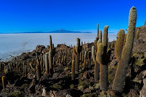
may the lithium force be with you by HAZ_Hikebot The world's largest salt flat, or playa, at over 3,900 sq mi in area(roughly 80mi x 60mi). It is in the Daniel Campos Province in Potosí in southwest Bolivia, near the crest of the Andes at an elevation of 11,995 ft above sea level. The Salar was formed as a result of transformations between several prehistoric lakes that existed around forty thousand years ago but had all evaporated over time. It is now covered by a few meters of salt crust, which has an extraordinary flatness with an average elevation variation within one meter over the entire area of the Salar. The crust serves as a source of salt and covers a pool of brine, which is exceptionally rich in lithium. The large area, clear skies, and exceptional flatness of the surface make the Salar ideal for calibrating the altimeters of Earth observation satellites. Following rain, a thin layer of dead calm water transforms the flat into the world's largest mirror, 80 mi across.
Salar has been used as a filming location for movies such as Star Wars: The Last Jedi (2017; as planet Crait), The Fall (2006), Salt and Fire (2016), The Unseen (2017), and several others. Geology Salar de Uyuni is part of the Altiplano of Bolivia in South America. The Altiplano is a high plateau, which was formed during the uplift of the Andes mountains. The plateau includes fresh and saltwater lakes as well as salt flats and is surrounded by mountains with no drainage outlets. Climate The area has a relatively stable average temperature with a peak at 70 °F November to January, and a low of 55 °F in June. The nights are cold all through the year, with temperatures between 16 and 41 °F. The relative humidity is rather low and constant throughout the year at 30% to 45%. The rainfall is also low at 0.039 to 0.118 in per month between April and November, but it may increase up to 3.1 inhes in January. Except for January, the number of rainy days is fewer than 5 per month. Economic Boost Located in the Lithium Triangle, the Salar contains a large amount of sodium, potassium, lithium, and magnesium, as well as borax. With an estimated 9,000,000 t, Bolivia holds about 7% of the world's known lithium resources(hole e cow); most of those are in the Salar de Uyuni. Lithium is concentrated in the brine under the salt crust at a relatively high concentration of about 0.3%. It is also present in the top layers of the porous halite body lying under the brine; however, the liquid brine is easier to extract, by boring into the crust and pumping out the brine. The brine distribution has been monitored by the Landsat satellite and confirmed in ground drilling tests. Following those findings, an American-based international corporation has invested $137 million to develop lithium extraction. However, lithium extraction in the 1980s and 1990s by foreign companies met strong opposition from the local community. Locals believed that the money infused by mining would not reach them. The lithium in the salt flats contains more impurities, and the wet climate and high altitude make it harder to process. No mining plant is currently at the site, and the Bolivian government does not want to allow exploitation by foreign corporations. Instead, it intends to reach an annual production of 35,000 t by 2023 in a joint venture with ACI Systems Alemania GmbH. Salar de Uyuni is estimated to contain 10 billion tonnes (9.8 billion long tons; 11 billion short tons) of salt, of which less than 25,000 t is extracted annually. All miners working in the Salar belong to Colchani's cooperative. Because of its location, large area, and flatness, the Salar is a major car transport route across the Bolivian Altiplano, except when seasonally covered with water. Name Salar means salt flat in Spanish. Uyuni originates from the Aymara language and means a pen (enclosure); Uyuni is a surname and the name of a town that serves as a gateway for tourists visiting the Salar. Thus Salar de Uyuni can be loosely translated as a salt flat with enclosures, the latter possibly referring to the "islands" of the Salar; or as "salt-flat at Uyuni (the town named 'pen for animals')". Aymara legend tells that the mountains Tunupa, Kusku, and Kusina, which surround the Salar, were giant people. Tunupa married Kusku, but Kusku ran away from her with Kusina. Grieving Tunupa started to cry while breastfeeding her son. Her tears mixed with milk and formed the Salar. Many locals consider the Tunupa an important deity and say that the place should be called Salar de Tunupa rather than Salar de Uyuni. Flora - Fauna The Salar is virtually devoid of any wildlife or vegetation. The latter is dominated by giant cacti (Echinopsis atacamensis pasacana, Echinopsis tarijensis, etc.). They grow to a height of about 39 ft. Other shrubs include Pilaya, which is used by locals to cure catarrh, and Thola (Baccharis dracunculifolia), which is burned as a fuel. Also present are quinoa plants and queñua bushes. Every November, Salar de Uyuni is the breeding ground for three South American species of flamingo feeding on local brine shrimps: the Chilean, Andean, and rare James's flamingos. About 80 other bird species are present, including the horned coot, Andean goose, and Andean hillstar. The Andean fox, or culpeo, is also present, and islands in the Salar (in particular Incahuasi Island) host colonies of rabbit-like viscachas. Source Wikipedia Gate Policy: If a gate is closed upon arrival, leave it closed after you go through. If it is open, leave it open. Leaving a closed gate open may put cattle in danger. Closing an open gate may cut them off from water. Please be respectful, leave gates as found. The exception is signage on the gate directing you otherwise. Check out the Triplogs. Leave No Trace and +Add a Triplog after your hike to support this local community. One-Way Notice This hike is listed as One-Way. When hiking several trails on a single "hike", log it with a generic name that describes the hike. Then link the trails traveled, check out the example. | |||||||||||||||||||||||||||||||||||||||||||||||||||||||


