Cerro Prieto (Dark Hill), AZ | HikeArizona
username
X
password
register
for free!
help


Cerro Prieto (Dark Hill), AZ

Guide 1 Triplog  0 Topics
  3 of 5 
Fav
Wish
0
details
drive
no permit
forecast
route  
stats
photos
triplog
topics
location
18 1 0
Statistics
tap icons for details
Difficulty 2.5 of 5
Route Finding 2 of 5
Distance One Way 0.85 miles
Trailhead Elevation 1,886 feet
Elevation Gain 800 feet
Accumulated Gain 806 feet
Avg Time One Way 1 hour
Kokopelli Seeds 3.54
 Interest Off-Trail Hiking & Peak
 Backpack Possible - Not Popular
 Dogs not allowed
feature photo
Photos Viewed All MineFollowing
18  2023-01-12 Mike_W
Author
author avatar Guides 44
Routes 66
Photos 2,521
Trips 213 map ( 1,187 miles )
Age 51 Male Gender
Location Tucson, AZ
Historical Weather
Trailhead Forecast
Radar Map
Expand Map
Preferred Nov, Dec, Jan, Feb → 9 AM
Seasons   Autumn to Spring
Sun  6:49am - 6:26pm
Official Route
 
0 Alternative
 
 Water


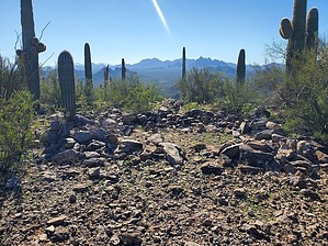
We hiked a dark hill on a bright day!
by Mike_W

 
Overview
Cerro Prieto (Dark Hill, in English) is a peak in the Samaniego Hills area within Ironwood Forest National Monument. This hill is named probably for the abundance of dark rock scattered all over it, some of which looked like lava rock. This hill is within 2 miles of the Sasco ruins.


Hike
From the parking spot outlined in the directions, start heading West. Within a few minutes, you will cross a wash. If you are a good scrambler, just head straight up the slope to the ridge. If you would prefer a more gradual climb, hike to one of the lower saddles to the Southwest. Once on the ridge, you will hike North along the ridgeline, then West to get to the top. The last 50 feet of elevation before the peak involves a fairly steep rocky climb. You could hike around some of these rocks by going further South to avoid the steep climb.

At the top, there's an old cross that needs some repair. You'll see a registry in the pile of rocks under the cross. The registry was a bit hard to find because it was small and buried quite deep. On the peak, near the high point and West of the high point, you'll also notice a lot of man-made circles of rocks that looked like the foundation of a home. Perhaps the Indian tribes used these areas for shelter from wind or sun, or to hide from opposing tribes. From the top, you'll also have nice views of Picacho peak.


Return the same way you came or cut down on the steepness by hiking further to the South before heading down the slope. Either way, you go, you will likely need to hike through some rocky terrain.

Check out the Official Route and Triplog.

Leave No Trace and +Add a Triplog after your hike to support this local community.

2023-01-14 Mike_W
  • NPS PDF Map
    area related
    NPS PDF Map
  • sub-region related

One-Way Notice
This hike is listed as One-Way.

When hiking several trails on a single "hike", log it with a generic name that describes the hike. Then link the trails traveled, check out the example.
WARNING! Hiking and outdoor related sports can be dangerous. Be responsible and prepare for the trip. Study the area you are entering and plan accordingly. Dress for the current and unexpected weather changes. Take plenty of water. Never go alone. Make an itinerary with your plan(s), route(s), destination(s) and expected return time. Give your itinerary to trusted family and/or friends.

 Permit $$
None


 Directions
or
or
 Road
High Clearance possible when dry

To hike
Take the Red Rock exit (exit 226) from I-10. If you came from Phoenix the exit puts you on Sasco road going West. If you came from Tucson you will need to get off the exit, turn left to go under the highway, then right on the connector road to get to Sasco road. Once on Sasco road, travel about 6.5 miles and then look for S La Osa Ranch road on your right. You will not turn here; this is just for reference. Continue for 0.1 more miles and look for a dirt road going Southeast. Take this road for 1.25 miles until you reach a junction. At the junction, turn right and continue for another 0.15 miles. Park off the side of the road. This is a good place to start the hike.
page created by Mike_W on Jan 14 2023 12:10 pm
helpcorrectionissue

end of page marker