Route Editor

| Guide | ♦ | 2 Triplogs | 0 Topics |
details | drive | no permit | forecast | route |
stats |
photos | triplogs | topics | location |
| 40 | 2 | 0 |
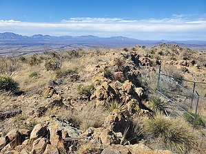
A piece of Colorado in Arizona by Mike_W  Overview OverviewThe Cerro Colorado mountains are south of the Sierrita Mountains and northwest of the Tumacacori Mountains. This hike is to the high point of the Cerro Colorado Mountains, which is also known as the Colorado Benchmark and has an elevation of 5,319 feet. There's a road going roughly 2 miles up. Then, from that point, there are 2 possible routes. One involves walking the ridgeline which is a total bushwhack, and the other involves taking a few unmaintained trails to get close to the peak. The trails do not go to the peak, so it's necessary to do a 1/3 mile bushwhack minimum, based on your route. Hike Continue hiking up the road from where you parked. If you parked where I parked, you will reach a split in the road after hiking roughly 0.4 miles. The right branch goes about 500 feet to some solar panels which I assume is used to power a water pump that operates inside a well called Surprise Well. Continue on the left branch. After you've hiked a total of roughly 1.5 miles, you should see a dam on your left, which is also named Horseshoe Tank. When I was there in early March, there was a good size pool of water. Continue on the road until you have hiked a total of roughly 2 miles and you will come to a saddle. You'll see 2 larger trees here and the road appears to end. From this location, you have basically 2 options on how to proceed.
Taking this route, it should be a total of roughly 2 miles to the peak. The ridge is to your north and it's a bushwhack. There are some areas of thick shin dagger that you'll need to go around. Over the next 0.8 miles, you will gain about 700 feet in elevation. The high point on this slope is roughly 4,850 feet in elevation. From here you will continue north along the ridgeline eventually dropping about 200 feet in elevation to a saddle. At this saddle you will see a trail crossing a barbed wire fence line. This trail is where you will end up if you happen to take option 2 (below), which is roughly 0.4 miles longer to arrive at this point but allows you to skip some of the bushwhack. Continue from the section below entitled 'From the barbed wire fence'... Options 2 - Follow the unmaintained trails Taking this route, it should be a total of roughly 2.4 miles to the peak taking the same route I took. You will continue on a faint trail heading southwest. The trail appears to head into a canyon. Within about 200 feet you will see two wooden posts near a saguaro cactus. Follow the trail through the wooden posts and down into the canyon. At times you will be in the canyon. Take the easiest way down. The trail will re-appear on the right side of the canyon. After about 0.4 miles the trail will curve to the right (north) and will approach a canyon. The trail is hard to follow at this point, but if you cross the canyon around 0.5 miles into this route, you should be able to pick up the trail on the other side. This trail appeared to head into the canyon, but we needed to go up, so we bushwhacked 500 feet northwest from this location and encountered another obvious trail at this location continuing north. Stay on this trail for roughly 0.9 miles and you should see a barbed wire fence. Continue from the section below entitled 'From the barbed wire fence'... From the barbed wire fence: You will step over the fence line at this location and continue north along the unmaintained trail. The trail will head north toward the peak, and then within about 1/2 mile of the peak, the trail crosses a canyon, starts to climb up, and go away from the peak. Not knowing where this trail went, we started our bushwhack from this location, aiming for the saddle just east of the peak. It is steep and rocky with slippery grass in many areas, so take your time and take solid steps. Once on top of the ridge, turn left and the peak should be about 0.1 miles to your west. At the peak, there's a fenced-in area with some solar panels. I placed a glass jar under a pile of rocks at the high point in March 2023 since I didn't find a registry. To get down, reverse these directions to get back to the barbed wire fence. Once there, you can take the trail or the ridgeline option as described above. No matter which option you take, you should arrive at the saddle which is where the road appears to end. When I did this hike in March 2023, I took the ridgeline up and the trail down. The trail was a more pleasant route even though it was a bit longer. If I did this hike again someday, I might be tempted to skip the ridgeline and take the trail both ways. But, there's no way that I can tell to avoid the final 1/3 mile bushwhack to the summit. Check out the Official Route and Triplogs. Leave No Trace and +Add a Triplog after your hike to support this local community. | ||||||||||||||||||||||||||||||||||||||||||||||||||||||||||||||||||||||||||||||||||||||||