Route Editor

| Guide | ♦ | 1 Triplog | 0 Topics |
details | drive | no permit | forecast | route |
stats |
photos | triplog | topics | location |
| 10 | 1 | 0 |
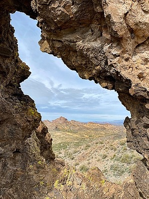
A not so very ordinary mountain, or name by GrangerGuy  Note NoteThere are two peaks in this area named Aubrey. Peak 2953’ is in the Aubrey Peak Wilderness and Aubrey Peak Bighorn Sheep Habitat Area of Critical Environmental Concern. The other, Peak 5080’ is about 8 miles from Wikiup. This guide is about the one in the wilderness. Overview Park in Centennial Wash and head toward the mountain, following the obvious ravine up to the ridge top. Climbing is generally easy, first through the meadow, then on pretty solid rock. At the ridgetop, turn right to the nearby summits. You will pass several small arches, Aubrey’s Eyes. When you stand on the top, you will be looking north across a deep notch to Aubrey Peak (2953’), no more than 30’ above you.
From the trailhead, follow Centennial Wash southwest. Although sandy, walking is pretty easy. Approximately one mile from the start, turn right up out of the main wash and start across pretty meadows of grass and creosote bush. As you climb, you will be cutting various small drainages at a diagonal, eventually following on the left side of the main wash. Where the main wash cuts a canyon through the cliffs, stay up against the cliff on your left to minimize the battle with the brush. Once through the first canyon, the way opens up again and the climb is mostly along or to the right of the wash on rock with solid footing. Above about 2500’, the route steepens, but I never found it uncomfortable or tricky. Arrive at the top of a ridge at 2800’, and the first of Aubrey’s Eyes come into view. Actually, two arches are interlocking there. Continue up the ridge easily to the right, eventually arriving at the local summit at 2921’, where you look across to the thumb of Aubrey Peak at 2953’ and be happy you did not try to climb that one. The approach would be much more challenging, and the final summit looks technical. A nice discussion of the geology of this area is in the book by Ivo Lucchitta, Hiking Arizona’s Geology, Mountaineers Books, 2001, Hike # 30. There is no shade on this hike, hence this is best a cool season hike. Check out the Official Route and Triplog. Leave No Trace and +Add a Triplog after your hike to support this local community. | |||||||||||||||||||||||||||||||||||||||||||||||||||||||||||||||||||||||||||||||||||||||||||||||||||