username
X
password
register
for free!
help
 

Durham Hills High Point, AZ

Guide 1 Triplog  0 Topics
  5 of 5 
Fav
Wish
0
details
drive
no permit
forecast
route  
stats
photos
triplog
topics
location
42 1 0
Statistics
tap icons for details
Difficulty 3 of 5
Route Finding 2 of 5
Distance Round Trip 5.74 miles
Trailhead Elevation 2,656 feet
Elevation Gain 534 feet
Accumulated Gain 1,022 feet
Avg Time Round Trip 3.5 hours
Kokopelli Seeds 10.85
 Interest Off-Trail Hiking, Seasonal Creek & Peak
 Backpack Possible - Not Popular
unreported if dogs are allowed
editedit > ops > dogs to adjust
feature photo
Photos Viewed All MineFollowing
42  2023-03-23 Mike_W
Author
author avatar Guides 59
Routes 91
Photos 3,708
Trips 241 map ( 1,370 miles )
Age 51 Male Gender
Location Tucson, AZ
Historical Weather
Trailhead Forecast
Radar Map
Expand Map
Preferred Nov, Dec, Jan, Feb → 9 AM
Seasons   Autumn to Spring
Sun  5:20am - 7:24pm
Official Route
 
0 Alternative
 
 Water


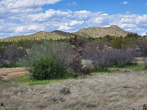
blue copper mining country
by Mike_W

Overview
The Durham Hills are roughly 35 miles north of central Tucson, as the crow flies. The hills are near the "Blue Copper Mine" and some private ranch property. The road going in passes through AZ State Trust land. This hike involves hiking in a wide open wash, hiking up a ridgeline, and on an old mining road, and is more of an open country hike rather than a bushwhack. The high point is near the north end of the ridgeline.


Hike
From where I parked, I walked north to the wide and long wash, called "Suffering Wash" that I just drove across minutes before. Strange name and no, I didn't happen to do any suffering during my wash walk. I did see a herd of cattle near where I parked. Hopefully, those cattle weren't the ones suffering. I followed this sandy and sometimes deep sand wash west for about 0.8 miles and then walked out of the north side and up the ridge. By the time I reached just over 1 mile, I saw an old road, which was probably an old mining road.

This road took me north and then northeast. The road seemed to take me to the ridgeline and then the road continued to a lower elevation, so this is where I started my "open country" hike going up the ridgeline. There were a few places where I needed to squeeze between some cactus, palo verde, and maybe a few catclaw bush, but overall, this hike was 90% open country and only 10% bushwhack. There were probably 2 small saddles along the way, but I eventually made it to the endpoint, found a glass jar registry, and signed my name.


Near the peak, I saw some larger birds perched up high and they flew off as I approached. I believe they were turkey vultures and I could tell by the reddish head. Along the entire hike, I saw a lot of wildflowers in March, lots of lupines especially, some yellow and orange poppies, chickory, Arizona daisies, miniature woolystar, and occasional blue chia. On the way down I took the road down further to see where it went and it continued west. When I started to get too far west, I dropped down to Suffering Wash and hiked back east to where I parked. Overall this was a good hike and it had a nice summit that extended for a good distance.


Check out the Official Route and Triplog.

Leave No Trace and +Add a Triplog after your hike to support this local community.

2023-03-25 Mike_W
    WARNING! Hiking and outdoor related sports can be dangerous. Be responsible and prepare for the trip. Study the area you are entering and plan accordingly. Dress for the current and unexpected weather changes. Take plenty of water. Never go alone. Make an itinerary with your plan(s), route(s), destination(s) and expected return time. Give your itinerary to trusted family and/or friends.

     Permit $$
    None


     Directions
    or
    or
     Road
    Paved - Car Okay

    To hike
    From Tucson: Take Highway 77 North to Oracle junction. Turn Left on Highway 79 and continue North for 15.3 miles, then turn left on W. Durham Wash Road. Then continue below...

    From Phoenix: Take the roads of your choice to Florence. From Florence take Highway 79 South for about 27 miles. Then turn right on W. Durham Wash Road. Then continue below...

    Continue here:
    ---------------
    This road crosses Arizona State Trust Land and there is private property to the Northwest. There is a sign indicating that you may need a permit, but 95% of hikers I know don't bother with the permit. I didn't see a single person all day, and the cows didn't seem to mind that I was there. They looked at me for a few minutes, perhaps confused, then they ran away.

    If unlocked, open the gate, drive in, and close the gate again. Follow this graded dirt road for about 1.8 miles. Then, you will look for a very sharp left turn. You will need to make sort of a U-turn here because it is a very sharp turn almost going back the way you came. Follow this road for 0.6 miles until you come to a wash. If there is any water proceed with extreme caution. When I was there it was dry and I didn't even need to turn on my 4-wheel drive. Continue across the wash and look for a road junction about 200 feet past the wash. This is a good place to park and should be on public land. In this area, I didn't see any private property signs.
    page created by Mike_W on Mar 25 2023 9:28 pm
     90+° 8am - 6pm kills
    Avoid Heat Illness - stay cool
    helpcorrectionissue

    end of page marker