Route Editor

| Guide | ♦ | 1 Triplog | 0 Topics |
details | drive | no permit | forecast | route |
stats |
photos | triplog | topics | location |
| 60 | 1 | 0 |
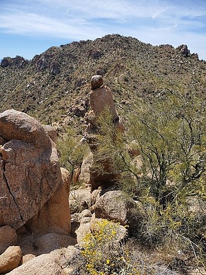
Maybe Solo should be called Dual by Mike_W  Overview OverviewThe West Silver Bell Mountains high point (3100) and Solo Peak (2947) are the two highest peaks in the West Silver Bell Mountains. These peaks are only about 1/4 mile apart from each other and along the same route, so it would make sense to hike both peaks on the same day. This hike is classified as "open country" with some nice graded roads along the way. Warning Along the ridgeline route, at many higher points and various saddles, we found A LOT of migrant debris including cans, plastic bottles, blankets, backpacks, clothing items, plastic, paper, etc. Not sure how recent it was.
We believe that the West Silver Bell Mountains high point MAY be officially named "Sawtooth Peak" because that's how the official survey marker read at the high point. The topo maps didn't seem to show a name. I'm familiar with the Sawtooth Mountain range and many of us thought it was a bit odd that this peak was named Sawtooth Peak because to our knowledge this peak is not in the Sawtooth Mountains. Hike Part of the challenge is making it to the starting point. It's quite a drive and it should be possible with a high-clearance vehicle unless there are any flowing creeks or water to drive through. From the starting point, start by walking the road south for roughly 1/4 mile. Look for a branch in the road heading East. Take this road east into the canyon. After traveling a total of 1/2 mile you will reach the end of the road. From this point, you should be able to continue up the canyon doing an "open country" hike. At times, there will be some brush to go around, but there are many good routes up and many animal trails along the way. We chose to stay on the right side of the canyon, away from all the brush and walked up toward the top of the ridgeline connecting Solo Peak with the West Silver Bell High Point (elev 3100). When you get higher up, you will need to cross a canyon branch which should be pretty easy to cross. Continue heading up the canyon until you have reached the ridgeline. You should reach the ridgeline after hiking a total of 1.15 miles. If you choose to hike to Solo peak (2947), there are a few good ways to get up there. A little scrambling is involved but you should not need to do any rock climbing. Near the top, stay west of the peak and you will see an easy way to reach the summit. At the summit, there was evidence of many turkey vultures by seeing the numerous white marks on the rocks. We found a registry at the top and signed our names. Next, we went back down to the saddle and continued south along the ridgeline toward the high point (3100). There were a few areas where we needed to drop below the ridgeline to get around rocky areas. We kept heading in the direction of the high point and entered the summit from the northwest side. We saw a survey marker with an arrow pointing at the high point but couldn't find the main survey marker. After searching around extensively, I noticed a curved piece of metal buried under some dirt near a high point. After brushing off a lot of dirt and gravel, I was able to uncover the survey marker, which may have not been seen by any other hikers in many years. After searching this area for several minutes there was no sign of a registry anywhere. We thought there may not have ever been a registry for this high point, since it wasn't classified as a peak, but simply a ridgeline high point. I happened to have a jar with me so I left it there, starting a new registry right near the official survey marker. Also, at the high point was some kind of antenna connected to a solar panel, battery, etc. It looked like older technology. Not sure what it was used for. We saw a lot of brittlebush, lupine, scorpion weed, some poppies, and even some nice-smelling lavender along the way. If you choose to take the loop that we took, you should be comfortable scrambling. The easier part of the hike was getting to the high point. Continuing down along the ridgeline and going down through the unnamed canyon was a bit more difficult and involved some scrambling. The easier route would be to go down the same way you came up. If you do this, the total round trip distance for the entire hike will be 4 miles instead of 5 miles.
Check out the Official Route and Triplog. Leave No Trace and +Add a Triplog after your hike to support this local community. | ||||||||||||||||||||||||||||||||||||||||||||||||||||||||||||||||||||||||||||||||||||||||