username
X
password
register
for free!
help
  🔥

Peach Knob 4718 - Santa Ritas, AZ

Guide 1 Triplog  0 Topics
  2 of 5 
Fav
Wish
0
details
drive
no permit
forecast
🔥
route  
stats
photos
triplog
topics
location
20 1 0
Statistics
tap icons for details
Difficulty 2.5 of 5
Route Finding 2 of 5
Distance Round Trip 1.5 miles
Trailhead Elevation 4,696 feet
Elevation Gain 427 feet
Accumulated Gain 498 feet
Avg Time Round Trip 1 hour
Kokopelli Seeds 3.99
 Interest Off-Trail Hiking & Peak
 Backpack No
unreported if dogs are allowed
editedit > ops > dogs to adjust
feature photo
Photos Viewed All MineFollowing
20  2023-04-20 Mike_W
Author
author avatar Guides 58
Routes 89
Photos 3,698
Trips 238 map ( 1,357 miles )
Age 51 Male Gender
Location Tucson, AZ
Historical Weather
Trailhead Forecast
Radar Map
Expand Map
Preferred Sep, Oct, Feb, Mar → 5 PM
Seasons   Autumn to Spring
Sun  5:22am - 7:18pm
Official Route
 
0 Alternative
 
 Water
Historic Fire Perimeteracres
🔥 2017 Sawmill Fire14.2k


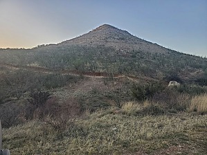
You won't find any peach trees on this hill
by Mike_W

Overview
The "Peach Knob" is a 400-foot hill just South of a mining area currently occupied by Cimbar Performance Minerals. Previously this mining area was occupied by Imerys Marble. There are many dirt roads going at least 2/3 of the way up this hill which are part of the route. Then, a short scramble is needed to get to the summit. Along the way, you will likely see blue and green copper and possibly other interesting rocks.


Hike
Start on the South or Southeast side of the Peach Knob. I started on the Southeast side, close to the entrance of the mine, which is a good route in my opinion. Walk North/Northwest about 150 feet until you reach the first dirt road. Take this road until you have traveled a total of 0.15 miles. From here the road makes a sharp left turn and then a sharp right turn before going further uphill. Continue uphill until you reach the next junction. At this junction, make a left turn and continue for roughly another 0.15 miles.

You'll see a road merging in from the right. Take this sharp right turn and follow the road for roughly 1,000 feet or 1/5 mile. The road will dead-end in this area and you'll see a dug-out area to the North. This is a good place to get on the ridgeline, heading up to the peak. Be careful as some of the ground near the dugout area might be loose. Once on the ridgeline, continue North/Northwest toward the high point.


You may need to weave around some brush (cactus, ocotillo, etc.). When you get to the first high point, you are not quite there yet. You will see another high point that is about 100 feet away that appears to have the same elevation as where you're standing. This is the true high point and where the registry is carefully placed until a small rock pile. Admire the views of Mt Wrightson, the surrounding Santa Rita mountains, and the mining area below you.


Check out the Official Route and Triplog.

Leave No Trace and +Add a Triplog after your hike to support this local community.

2023-04-21 Mike_W
    WARNING! Hiking and outdoor related sports can be dangerous. Be responsible and prepare for the trip. Study the area you are entering and plan accordingly. Dress for the current and unexpected weather changes. Take plenty of water. Never go alone. Make an itinerary with your plan(s), route(s), destination(s) and expected return time. Give your itinerary to trusted family and/or friends.

     Permit $$
    None


     Directions
    or
    or
     Road
    Paved - Car Okay

    To hike
    Take I-19 South from Tucson to Exit 75 (Sahuarita Road). Turn left onto Sahuarita Road and continue for 2.4 miles. Turn right on Santa Rita Road and continue for 11.4 miles. Take a slight left onto S. Helvetia Road. Continue for 1 mile and stay right at the next junction. Continue for 1/4 mile more and turn left at the next junction. Continue for less than 1/5 mile and park on the side of the road before the gate going into the mining area. The mine is private property and the Peach Knob, I believe, is just outside of the mine's property line.
    page created by Mike_W on Apr 21 2023 6:17 pm
     90+° 8am - 6pm kills
    prehydrate & stay hydrated
    helpcorrectionissue

    end of page marker