Route Editor

| Guide | ♦ | 1 Triplog | 0 Topics |
details | drive | no permit | forecast | route |
stats |
photos | triplog | topics | location |
| 18 | 1 | 0 |
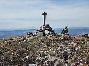
A manzano a day keeps the doctor away by DixieFlyer  Manzano Peak (elevation of 10,098 feet and prominence of 3,238 feet) is the highpoint of Torrance County. It is also the highpoint of the Manzano Mountain Wilderness. Etymology Manzano is the Spanish word for "apple". In the 1700s explorers visiting this area noted some apple trees growing in a village near these mountains. The trees appeared very old and nobody knew how or when they arrived, as apple trees were not native to the area. The village and mountains both became known as Manzano.
The shortest route to Manzano Peak is to do an out-and-back hike from the Kayser Mill Trailhead. That is the route described in this guide. Another route is to do an out-and-back hike from the Pine Shadow Trailhead. Such a hike would be around 11 miles long with 3,000 feet of elevation gain. One could do a CCW loop hike by first taking Cottonwood Trail #79, then in sequence taking Kayser Mill Trail #80, the Manzano Crest Trail, and the Pine Shadow Trail back to FR 422. Then hike on FR 422 for a mile or so back to the Cottonwood Trail. These alternate routes are beyond the scope of this guide. Check trip reports to see if others may have utilized these routes. Hike The hike begins and ends at the Kayser Mill Trailhead. Take Kayser Mill Trail #80 for 3.3 miles until you come to a grassy saddle at a junction for the Manzano Crest Trail. Then make a left turn onto the Manzano Crest Trail and go south for 0.65 miles to a signed junction that has a spur leading to the left that goes to the Manzano Peak summit. Then follow this spur trail for 0.25 miles to the summit. Most of the elevation gain on the hike will be on the climb to the Manzano Crest on the Kayser Mill Trail. In fact, the Manzano Peak summit is not much more than a bump along the ridgeline. However, despite this, there are excellent views at the summit in 3 directions. After taking time to enjoy the views at the summit, return the way that you came. Note This is entirely a class 1 hike on marked trails. Historically, the condition of the trails has ranged from good to poor. The trails were in good shape when the author of the guide did the hike, but there is no guarantee that the trails will always be in this condition. If you have any questions about trail or road conditions, it is best to contact the Mountainair Ranger District of the Cibola National Forest. Their phone number is 505-847-2990. The best time to do the hike is spring and fall, although, with an early start, the hike will generally be OK in the summertime. The area can have some monsoon storms in the summer, so it is a good idea to check weather forecasts during the monsoon season. Check out the Official Route and Triplog. Leave No Trace and +Add a Triplog after your hike to support this local community. | ||||||||||||||||||||||||||||||||||||||||||||||||||||||||||||||||||||||||||||||||||||||||||||||||