 Route Editor

| Guide | ♦ | 8 Triplogs | 0 Topics |
details | drive | no permit | forecast | route |
stats |
photos | triplogs | topics | location |
| 43 | 8 | 0 |
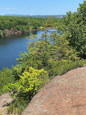
Basalt ridges rock! by GrangerGuy  The Metacomet Trail is a segment of the New England National Scenic Trail (NET) that runs from Long Island Sound to the Massachusetts-New Hampshire border. It follows along the Metacomet Ridge from the town of Berlin to the town of Suffield at the Mass border. It is marked by blue blazes throughout its length. It is sometimes indicated as 51 miles long, but it is 62.7 miles long. Much of the trail is on top of the ridge; the views from the ridge are impressive on nice days, but often hidden by the trees. History The ridge is named after a chief of the Wampanoag people, who lived during the early colonial period, who first tried to live with the colonists, and then fought them. The Metacomet Ridge itself runs from Long Island Sound almost all the way to Vermont and New Hampshire. One of the main components, basalt, known locally as traprock, can be seen at outcrops at many places along this hike.
The hike is described from south to north, beginning at the intersection of Kensington Road and Orchard Road in Berlin. Officially the trail starts at the intersection of US-5 and Orchard Road, but it is a road walk from there to Kensington Road; only through hikers on the NET would bother with that. It is described here in segments that are easily managed as day hikes. Kensington Road to Edgewood Road 11.9 mi The way heads south, then west to Hubbard Park in the town of Meriden, where you climb first East Peak, with its curious Castle Craig, then far down for no apparent reason, and then back up West Peak, the site of the first FM radio broadcast tower. Then, the trail gently descends to Edgewood Road, where there is good parking. It continues 1.4 miles north on Edgewood Road to the intersection with Southington Road where it enters the forest. Edgewood Road to Crescent Lake 10.3 mi This section has some navigation challenges and a couple of serious scrambles. Pay attention to the official GPS track and the blue blazes. If the blazes disappear, you are off the track. Along here, you will climb Ragged Mountain, with many spectacular viewpoints. You will also pass Rogers Orchards' store during a road walk, with fresh fruit and cider. There is parking and an outhouse at Crescent Lake, AKA Plainville Reservoir, reached by a connector trail included in the mileage listed, but the gate hours are odd, so you might want to park on a side street. Crescent Lake to Farmington Reservoir 9.7 mi Although many maps identify this area as Sunset Rock State Park, no such park actually exists. The land around Crescent Lake is owned by the towns of Southington, Plainville, and New Britain. The trail wanders through lovely woodland, eventually coming out near the intersection of I84 and CT-72, which requires a 1.2-mile road walk to get around. Once past the roads, you climb up to Pinnacle Rock, a popular rock climbing area, down sharply, then up to the top of Rattlesnake Cliffs, which is a popular destination coming in from the north. Other features of this section include a decommissioned Nike missile base and Will Warren's Den. Farmington Reservoir to Hartford Reservoir #6 8.9 mi There is good parking on Colt Highway (CT-6) reached by a short connector. Cross CT-6 and bear right as the trail climbs swiftly to the ridge, with some views as you go. Once across CT-4, the route becomes decidedly suburban, alternating between woods and quiet streets, until it passes into East Hartford watershed forest. Hartford Reservoir #6 to Wintonbury Road 9 mi There is excellent parking at Hartford Reservoir #6 and an outhouse. Across Albany Ave. and a few hundred yards west, there is ungated trail parking as well. The trail heads north along the reservoir along a flat dirt path where you are likely to see many people, before turning up the hill to Talcott Mountain State Park with the Heublein Tower and museum. The Tower is open Friday through Monday. There are a picnic shelter, water, and restrooms at the tower. Continuing north, the way passes into Pennwood State Park, with good views from The Pinnacle, before descending to Wintonbury Road. Wintonbury Road to Turkey Hills 7.5 mi Along this section, there are some nice cliff-top viewpoints, and the trail follows the Farmington River with some photo opportunities. There is also quite a bit of poison ivy in this section. It also follows closely along a large gravel pit, which you can hear but not see, at least in the summer. Turkey Hills to Rising Corner 8.1 mi This is the best section of the Metacomet Trail. There are many good viewpoints and the trail is easily navigated. The trail is wide and has long flat sections along the ridge top and very little poison ivy. The first viewpoint after leaving Turkey Hills Road has the broadest expanse. I could see all the way down to the Heublein Tower in Simsbury. Camping The last segment contains the Windsor Locks Scouts Primitive Tentsite, the only legal camping spot on the whole 62.7 miles of the Metacomet Trail at about Lat: N 41°58.4051', Lon: W 72°44.3741'. Although backpacking is encouraged, the NET website, newenglandtrail.org, provides more information for through-hikers and discourages stealth camping on private land along the trail. Note This trail is maintained by the Connecticut Forest and Park Association. More information can be found on their website at ctwoodlands.org Gate Policy: If a gate is closed upon arrival, leave it closed after you go through. If it is open, leave it open. Leaving a closed gate open may put cattle in danger. Closing an open gate may cut them off from water. Please be respectful, leave gates as found. The exception is signage on the gate directing you otherwise. Check out the Official Route and Triplogs. Leave No Trace and +Add a Triplog after your hike to support this local community. One-Way Notice This hike is listed as One-Way. When hiking several trails on a single "hike", log it with a generic name that describes the hike. Then link the trails traveled, check out the example. | |||||||||||||||||||||||||||||||||||||||||||||||||||||||||||||||||||||||||||||||||||||


