 Route Editor

| Guide | ♦ | 1 Triplog | 0 Topics |
details | drive | no permit | forecast | route |
stats |
photos | triplog | topics | location |
| 5 | 1 | 0 |
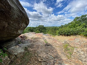
Scenic Paws-ibilities at Wolf Rock by GrangerGuy The southern part of the Nipmuck Trail is divided into two branches, West and East. This guide is for the West Branch that begins on Puddin Lane in Mansfield Center, and winds north to an intersection with the East Branch and the North main segment of the Nipmuck Trail near the “50-Foot Cliff”. History The Nipmuck Trail is named after the Nipmuc people who inhabited this area before the arrival of European colonists. The Nipmuc tribe has never been federally recognized, although it is recognized by the State of Massachusetts.
Park in the Sawmill Brook Preserve parking lot on the north side of Puddin Lane. The blue-blazed Nipmuck Trail heads straight out the back of the parking lot. There are no facilities at the lot. In less than 0.1 miles, at a highly over-engineered bridge, the trail turns sharply left away from the more obvious, wide track. It climbs pleasantly first through the Sawmill Brook Preserve and other land owned by the Town of Mansfield, then through the Wolf Rock Preserve owned by Joshua’s Trust. Within the Wolf Rock Preserve is Wolf Rock, the only viewpoint you will encounter on this hike. The views from the top are extensive. Wolf Rock is a popular climbing destination as well. Leaving Wolf Rock, the trail descends gently to Crane Hill Road and goes directly across. There is roadside parking here. Between Crane Hill Road and Browns Road, the trail quality is poor, first negotiating many boulders, then heading straight up the fall line to thread between a couple of houses. North of Browns Road, there are signs indicating trail distances to Schoolhouse Brook Park, but you won’t be able to tell when you get there. The park looks like all the other forest. Within this Park, there is one confusing trail intersection near the top of the hill. Make sure you look for the blue blazes to keep you on the right track. The way continues north across Clover Mill Road, where there is parking, winding its way over to Schoolhouse Brook, crosses it, and turns left, following it upstream to the dam at Bicentennial Lake. Here there is a park with swimming and restrooms. Leaving the lake, the trail crosses some private land, a gas pipeline, and then follows the stone wall along someone’s lawn to come out on Spring Hill Road, where it turns right. Spring Hill Rd. is pleasant, but the subsequent crossing of Storrs Road (CT-195) is not, with its curves and high-speed traffic. The trail turns left along Storrs Rd. a short distance, turning in at the Mansfield Historical Society, which has a large parking lot in back. The trail continues out the back of the parking lot, following a pleasant old dirt lane, and finally meets up at the pipeline easement with the East Branch and North Branch of the Nipmuck. Note This trail is developed and maintained by the Connecticut Forest and Park Association. Check out the Official Route and Triplog. Leave No Trace and +Add a Triplog after your hike to support this local community. One-Way Notice This hike is listed as One-Way. When hiking several trails on a single "hike", log it with a generic name that describes the hike. Then link the trails traveled, check out the example. | |||||||||||||||||||||||||||||||||||||||||||||||||||||||||||||||||||||||||||||||||||||


