 Route Editor

| Guide | ♦ | 3 Triplogs | 0 Topics |
details | drive | no permit | forecast | 🔥 route |
stats |
photos | triplogs | topics | location |
| 4 | 3 | 0 |
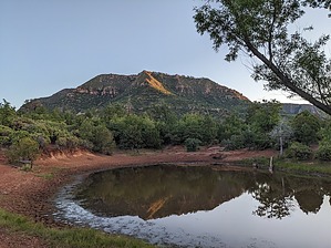
Tonto Tabletop Traipse by pseudalpine   Overview OverviewThere are shorter, more direct, serious bushwhack routes to this summit, but this relatively scratch-free, standard route follows FR1245 to the tank and then ascends the less vegetated north slopes to 6686. It's also possible to easily tick this summit from a Highline Trail side trip. Hike Follow FR1245 north, gradually up the hillside road. At the 0.75-mile mark, FR1248A merges from the east (right). When we last hiked this route, FR1245 had recently been plowed and pruned to this junction. The hike from this point afterward isn't maintained and becomes rockier and more rutted. It also sweeps to the west and becomes much steeper, ascending the south side of an unburned and pleasant valley. Once on top of the mesa, a few different tracks are heading north, through the Manzanita tunnels to the tank. The north slopes of the butte aren't as overgrown, so one can more simply wrap around that side of the hilltop to reach the summit.
The peak views aren't particularly spectacular because of the overgrowth, but this hike is still a decently tranquil stroll to one of the many Mogollon Rim foothill crowns. Total roundtrip distance would be a bit over five miles (depending on approach options). Check out the Official Route and Triplogs. Leave No Trace and +Add a Triplog after your hike to support this local community. One-Way Notice This hike is listed as One-Way. When hiking several trails on a single "hike", log it with a generic name that describes the hike. Then link the trails traveled, check out the example. | ||||||||||||||||||||||||||||||||||||||||||||||||||||||||||||||||||||||||||||||||||||||||||||||||||


