Route Editor

| Guide | ♦ | 29 Triplogs | 0 Topics |
details | drive | no permit | forecast | route |
stats |
photos | triplogs | topics | location |
| 341 | 29 | 0 |
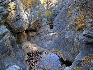
Canyons are inherently risky. Flash floods occur without notice on sunny days. Technical skills & surrounding topography knowledge required yet does not eliminate risk.
Mmmm, canyon stew! by nonot  Overview OverviewClass 3 canyoneering into West Clear Creek, rappels up to 75 feet. It finishes with some moderate downclimbs and some yummy wades through canyon stew! Warning This is a technical canyon; you will need a full set of canyoneering gear (including helmets) to attempt this loop. Furthermore, due to length and difficulty, I would recommend beginners try easier routes first. Oh yeah, don't bring your new clothes on this hike; you might not be able to wear them in public afterward without being referred to as "that smelly guy". Wilbur will be cold, depending on conditions, a shorty wetsuit would probably be fine in summer if you're warm-blooded, but some may prefer a full-body wetsuit, especially on cooler days. I'd recommend you bring a 200 ft rope. I didn't see any particularly difficult rope pulls, but bringing a backup rope is never a bad idea.
ALWAYS CHECK THE WEATHER BEFORE HEADING INTO A SLOT CANYON; DON'T PUT YOURSELF AT RISK OF A FLASH FLOOD! History Since 2006 this published canyon has about 30 registered descents. Thus far, the canyon has sprouted a few bolts in places natural anchoring opportunities are not convenient. Please do your part to keep this canyon clean and avoid placing any more bolts; no more are necessary. Hike From the forest roads intersection, head east about 3/4 mile on the road, go N at the intersection another ~1/4 mile, then bushwhack your way east to drop into Wilbur. There is a lot of New Mexico Locust to plow through, so pick your route and earn your canyon! Once at the bottom, Wilbur is fairly flat and brushy for a while. After yesterday's torrential rains, the upper canyon had about 10 hours to dry out, and it was filled with clear water in some shallow sections. After heading down the creek for about 20 minutes, we bypassed a possible rappel on canyon right LDC. After splashing through several potholes and some easy downclimbs, we reached another drop of about 15 feet with a choice of rappelling off a deadman on left or downclimbing a suspect log on canyon right. We rigged the first rappel here, although, in drier conditions, the logs might not be so slippery. Once down this first drop, few opportunities of escape exist. The next rappel is about 75 feet from a tree on right LDC. It would probably be good to have a 200 ft rope for this one depending on where the anchor is set up. We signed the canyon register and rigged our rappel. On the way down, I had to clear the way of some deadfall/log jams that had been washed into the canyon and jammed into the chute. I apparently missed one because the next rappeller got a jab in the ribs from a branch. 2/3 of the way down is a semi-keeper, although it was full of logs one could use to arrange to climb out. Furthermore, those in the know could easily avoid getting into the pothole at all by maneuvering around it while on rappel. Continue to the bottom, but don't coil your rope after everyone is down; the next rappel is just over the enormous chockstone boulder. This next rappel consists of a 35 (?) foot rappel from a pinch point on left LDC into a dry grotto, followed by a 20 ft walk and another 20 feet rappel into a bowl. Don't pull your rope after the first 30 feet; there is little to anchor to on the platform halfway down. In the bowl, you would be in a keeper, except an enormous log makes for a convenient platform. Once everyone is down into the bowl and on the log, pull the rope. Use the log to climb to the keyhole and rig a 50-foot rappel off the ring bolt (with webbing...wtf?) on left LDC. Very short people or kids may need a partner to assist in getting from the log into the keyhole. My memory is a little dim here. I remember downclimbing some of the chutes that had rappels rigged, but we wanted to challenge ourselves. There were about 3 moderately difficult downclimbs. I think we belayed some of the members down these climbs; they are steep and moderately high (12-25 feet). LaMAR. Towards the end, you get into some very narrow slots and some excellent canyon stew. Wade through this and set up the final 60 ft or so from a bolt and rappel into West Clear Creek, and you're done...not. Turn left and head for the Calloway Trail #33. A decent trail is on the right bank for the first third of a mile. After this is a 1.5-mile locust gauntlet, or if you choose, trying to walk down canyon mid-stream on algae-covered rocks and slipping and making a fool of yourself. You will be thankful to eventually find Calloway Trail and hike the 750 ft uphill back to the trailhead. Walk south along the road until you get back to your vehicle. Note After recent rains, most will be unable to make it to Calloway Trail. We got as close as we could and hiked an extra 5 miles that day too, and from the canyon through the mud, making for a long day. On reaching the vehicle at dusk, we found 1-2 other good-sized trucks stuck in the mud just past where we had stopped. Beware the sudden thunderstorms that could trap you there, or bring a 4x4 with locking front and rear diffs. Check out the Official Route and Triplogs. Leave No Trace and +Add a Triplog after your canyon trip to support this local community. | ||||||||||||||||||||||||||||||||||||||||||||||||||||||||||||||||||||||||||||||||||||||||||||||||||||||||||||||||||||||||||||||||||||||||||||||||||||||||||||||||||||||||||||||||||||||||||||||||||||||