Route Editor

| Guide | ♦ | 48 Triplogs | 0 Topics |
details | drive | no permit | forecast | 🔥 route |
stats |
photos | triplogs | topics | location |
| 394 | 48 | 0 |
Canyons are inherently risky. Flash floods occur without notice on sunny days. Technical skills & surrounding topography knowledge required yet does not eliminate risk.
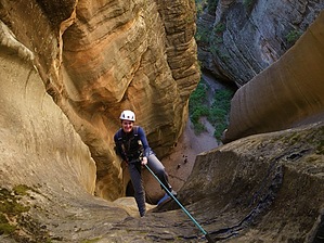
Cassidy Canyon's neighbor by nonot  Overview OverviewA short technical canyon that can be an easy romp or a deadly trap, depending on conditions. DANGER THIS CANYON CAN CONTAIN KEEPER POTHOLES, CANYONEERS MUST BE PREPARED WITH KEEPER EXIT STRATEGIES! DON'T DO THIS CANYON ALONE! DON'T PULL YOUR ROPE UNTIL SOMEONE IS OUT OF EACH KEEPER IN CASE A RETREAT IS NECESSARY!
ALWAYS CHECK THE WEATHER BEFORE ENTERING A SLOT CANYON, DON'T PUT YOURSELF AT RISK OF A FLASH FLOOD! Warning This is a technical canyon with some semi-keeper and keeper potholes, you will need a full set of canyoneering gear (including helmet) and 400 ft of rope for the last 180 ft rappel. This is not a canyon to be taken lightly if water levels are low this canyon can become a deadly trap. Bring proper gear and rehearse your exit techniques before committing. This canyon has some deep water and may be quite cold. A shorty might be fine for summer if you're warm-blooded, but a full wetsuit or drysuit might be preferable, especially if conditions are difficult and you spend a lot of time in the water and/or potholes. I am not responsible if you end up trapped in this canyon, death by hypothermia. 2x200ft ropes and a 60 ft rope will make you well prepared rope-wise. Experienced canyoneers only, you are responsible for self-evaluating your abilities. Read those danger warnings again, read the legalese at the bottom of the page. Are you sure you're ready for this? Are you a danger to yourself or others? Don't do this canyon alone! Don't do this canyon unprepared! History First descent: unknown. While filming a PBS series Anyplace Wild, Rich Carlson and the group took a film crew and John Viehman through this canyon. Joking around with the theme they were "Butch Cassidy and the Sundance Kid", the name stuck. Later Rich showed it to Todd (of Todd's hiking guide). However, the secret couldn't stay secret for long and this gem was revealed to the public. Hike From the Point TH, try to find the old road that heads southeast after a while the road peters out and you bushwhack through some locust bush and some easy downclimbing to reach canyon bottom. Downstream you will encounter some shallow potholes and wading through gunk. After 20 minutes from the TH, we reached a rappel, sign the register and then rappel 7 feet to a ledge and another 15 ft to the bottom. We pulled our rope and resumed a speedy descent. We cruised through several more potholes, did a steep downclimb, climbed down a slippery log, splashed some more until we reached a pothole at a bend in the canyon, one of the keepers. Past this is another rappel which you rig, then walk 10 feet to rappel 20 feet into a bowl. This bowl is a deep keeper and you will have to fight to get out of the pothole and into the precarious keyhole. Once in the keyhole downclimb a slick log 10 feet. Rig your final rappel, 180 ft, don't be HAD (Harness, Anchor, Device). Make sure you rig enough friction if going single strand! Packs should be hung from harnesses! Rope joining knots should be properly tied, blocks secure! Of course, you should know all this already, if not then should you even be thinking about attempting this canyon right now in your canyoneering career? The last 130 ft of the rappel into the grotto is free-hanging, enjoy it while you can. Send down an experienced canyoneer first to untwist any tangles and provide a fireman to any novices. The last person should check the rigging before committing, the pull is not bad, only time-consuming. After pulling and coiling your rope greet any fans you made and hike left, downstream, through West Clear creek to the Point Trail. Head up the steep trail 750 ft to your car. Check out the Official Route and Triplogs. Leave No Trace and +Add a Triplog after your canyon trip to support this local community. | |||||||||||||||||||||||||||||||||||||||||||||||||||||||||||||||||||||||||||||||||||||||||||||||||||||||||||||