Route Editor

| Guide | ♦ | 42 Triplogs | 0 Topics |
details | drive | no permit | forecast | 🔥 route |
stats |
photos | triplogs | topics | location |
| 138 | 42 | 0 |
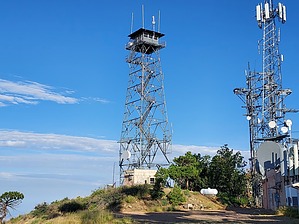
Ord Lite by DixieFlyer   Overview OverviewThis hike goes to the summit of Mount Ord (elevation of 7,128 feet and prominence of 2,408 feet), which is northeast of Phoenix in the Mazatzal Mountains. The entirety of this hike is on well-graded forest roads. Etymology Mount Ord is named for Major General Edward Otho Cresap Ord, who commanded U.S. troops in Arizona in 1869. Ord was noted for an uncompromising attitude toward the Apache. [Source: Arizona's Names (X Marks the Place) by Byrd Howell Granger]
This is about as straightforward of a hike that you will do. From the 626 TH, take FR 626 all the way to the summit. The first 3.2 miles of the hike to a junction with FR 27 are in a northeast direction. At that point, the road goes south to the summit. At the 5.1 mile mark, you will come to a locked gate, beyond which authorized vehicles only are allowed. However, hikers can continue on the road past this gate. At the 5.5-mile mark you will come to a fork in the road; take the right fork for another 0.4 miles to the summit. At this fork, there is a sign pointing right for the Mount Ord Fire Lookout. As you continue past the fork toward the summit, if you look to your right you have some nice views of Horseshoe Reservoir and Bartlett Reservoir. The summit has some nice views to the south of Four Peaks and Roosevelt Lake, and to the east of the Sierra Ancha range. The Mount Ord highpoint is underneath the Fire Lookout Tower at the summit. As described, this is an out-and-back hike so reverse your steps to get back to the trailhead. Synopsis Being a road walk, this is not the most exciting hike in the world. However, it has decent mileage/elevation gain along with a good surface to walk on, so it is a good workout hike. The elevation is high enough that you can escape some of the Phoenix heat in the summertime with an early start. Gate Policy: If a gate is closed upon arrival, leave it closed after you go through. If it is open, leave it open. Leaving a closed gate open may put cattle in danger. Closing an open gate may cut them off from water. Please be respectful, leave gates as found. The exception is signage on the gate directing you otherwise. Check out the Official Route and Triplogs. Leave No Trace and +Add a Triplog after your hike to support this local community. | ||||||||||||||||||||||||||||||||||||||||||||||||||||||||||||||||||||||||||||||||||||||||||||||||||||||||