 Route Editor

| Guide | ♦ | 1 Triplog | 0 Topics |
details | drive | permit | forecast | map |
stats |
photos | triplog | topics | location |
| 24 | 1 | 0 |
No canyon, plenty of Belle by chumley So, when you've picked up your permit at the Kings Canyon Visitor Center in Grant Grove, and find your way to the Rowell Meadow Trailhead (about a 45 minute drive, with only the last two miles unpaved, but still sedan accessible in normal weather) its time to get going. There is a pit toilet at the trailhead, but a previously available water spigot has been capped off and is no longer working.
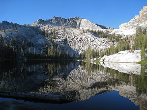
As the trail rounds the mountain and heads back toward the east, you reach the Jennie Lakes Wilderness boundary at 1.25 miles. At this point, the trail enters a more sheltered forest, with Rowell Creek now paralleling the trail for a short stretch. At 2.1 miles you pass the junction for the JO Trail, and a few hundred feet later, the trail passes Rowell Meadow and the first available campsite on this trail at the snow survey cabin. The steady climb from the trailhead to Rowell Meadow covers 925 feet. 0.4 miles past the cabin at Rowell Meadow, the trail reaches a three-way split. One trail heads to the north and heads to the Marvin Pass trailhead. The center trail is signed for Roaring River, and heads toward Comanche Meadow and Sugarloaf Creek. Heading down this trail requires a different NPS permit for the Sugarloaf Trail. The trail to the right says to Seville Lake, and that's the direction to go. (Note: My GPS track incorrectly heads down the Sugarloaf trail before heading cross-country back to the correct trail. Don't go that way!) The trail slowly climbs about 300 feet in about 1.5 miles to the Kings Canyon National Park boundary, at the crest of a hill. From here, the trail heads down a very steady 800 foot descent for 1.5 miles to the small creek in Belle Canyon and another trail junction heading northeast to Roaring River and Sugarloaf. Here the trail up Belle Canyon leads to Seville Lake, 1.1 miles away. Skipping the spur to Seville Lake, we continued on the trail toward Lost Lake and Ranger Lakes. The trail climbs about 500 feet out of Belle Canyon over 1.25 miles before crossing a small crest and turning up a dry drainage toward Lost Lake. Its worth noting that on USGS topo maps its here that the trails to Lost Lake and Ranger Lake split. This is not the case. There is no trail junction here, and the trail to Ranger Lake splits about .75 miles up the Lost Lake drainage. (See my GPS route for clarification). Signs at the trail junction indicate an additional .5 miles to Lost Lake, and 1.5 miles to Ranger Lakes. The spur toward Lost Lake climbs another 300 feet to the spectacular lake at 9,127 feet, nearly 1,500 feet below the glacial-carved granite of Twin Peaks. There are three campsites at the lake with fire rings, and even a bear locker if you'd like to avoid having to carry a bear canister. If you continue on the trail toward the Ranger Lakes, the trail takes a short 200 foot drop before climbing 400 feet over the last mile to the lake. During the climb, the trail leaves the protection of the forest and enters more exposed granite with expansive views. At the top of the climb, the trail enters the pines once again, and the junction to Ranger Lake heads to the right, indicating just .1 mile. There are five campsites with fire rings at Ranger Lake, and two bear lockers. From Ranger Lake, the trail continues up over Silliman Pass (the boundary between Kings Canyon NP and Sequoia NP) and down to Twin Lakes on the west side of the pass. This section of the trail is referred to as the Twin Lakes trail by the NPS, but you can find my description of it on HAZ under the Silliman Pass Trail. Check out the Triplog. Leave No Trace and +Add a Triplog after your hike to support this local community. One-Way Notice This hike is listed as One-Way. When hiking several trails on a single "hike", log it with a generic name that describes the hike. Then link the trails traveled, check out the example. | ||||||||||||||||||||||||||||||||||||||||||||||||||||||||||||||||||||||||||||||||||||||||||||||||||


