 Route Editor

| Guide | ♦ | 1 Triplog | 0 Topics |
details | drive | permit | forecast | map |
stats |
photos | triplog | topics | location |
| 12 | 1 | 0 |
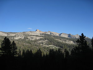
This trail ain't no JOke by chumley North of JO Pass, the trail is in the Jennie Lakes Wilderness of the Sequoia National Forest, and south of the pass, the trail is in Sequoia National Park. The permits for spending any nights in the National Park along the JO Pass Trail are issued at the Kings Canyon Visitor Center in Grant Grove. Make sure to pick up a campfire permit (free) as well, since the Sequoia National Forest requires one should you camp on forest land.
The trail begins in a nice little valley at a great camp spot with a fire ring on the banks of Clover Creek. This is the closest camp spot to the Twin Lakes where a campfire is allowed. (Though it's no easy hike uphill to get there!) It becomes quickly apparent that this trail is not nearly as well traveled as others in the area. Grasses and low plants encroach on the trail, though not enough to make it difficult to follow. A slow and easy climb through open grasses moves into the pines and the slope of the climb increases noticeably. After .5 miles, the trail moves out of the trees and an open hillside with some low grasses presents itself in front of you. The trail takes a nearly straight-up approach on this open hillside, and the footing is a bit sandy. Over the next .8 miles, the trail climbs about 600 feet steadily before the grade eases to a much more moderate climb to the top of the pass over the final .6 miles. Most of the climb to the pass is in lightly wooded forest, with some sandy footing and occasional boulders. Though during the steepest climb on the open hillside, there are great views south of a beautiful stepped ridge below Mt. Silliman. There's a reliable source of water in a gently flowing creek at Patee Meadow just a few hundred yards below the pass. At the 1.9 mile mark, you cross the pass, and leave Sequoia National Park, entering Sequoia National Forest, and the Jennie Lakes Wilderness Area. There's a trail heading west from the pass down to Jennie Lake. There's a camping available at Jennie Lake and that trail continues to the Big Meadows trailhead. From the pass, the JO Pass trail continues on an easy downhill grade to a creek at 3.4 miles. After a very brief climb, the trail continues its descent. At about 4.6 miles, the trail reaches the junction with a trail to Weaver Lake and on to the Big Meadow trailhead. From this junction, the trail continues for the final mile, climbing briefly after a creek crossing, and then traversing flat terrain in an unusually green and fertile area that is below Rowell Meadow, shortly after crossing Rowell Creek. The trail ends at the junction, where you can continue 2.2 miles downhill to the Rowell Meadow trailhead, or head east a few hundred yards to Rowell Meadow and a nice campsite. Check out the Triplog. Leave No Trace and +Add a Triplog after your hike to support this local community. One-Way Notice This hike is listed as One-Way. When hiking several trails on a single "hike", log it with a generic name that describes the hike. Then link the trails traveled, check out the example. | ||||||||||||||||||||||||||||||||||||||||||||||||||||||||||||||||||||||||||||||||||||||||||||||||||


