Route Editor

| Guide | ♦ | 2 Triplogs | 0 Topics |
details | drive | no permit | forecast | route |
stats |
photos | triplogs | topics | location |
| 27 | 2 | 0 |
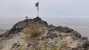
Yuma Pie! by chumley  Note NoteLegal vehicle access to this trailhead is in dispute. Read the warning below. Overview This classic desert mountain trail climbs steadily, with a hundred-yard stretch of hands-required scrambling and some loose scree just a few minutes below the summit.
The trail is named after the late Dr. Lester "Jester" Olin, longtime Yuma resident and OBGYN. Semi-reliable internet reports say he was the key figure in the creation, construction, and early maintenance of this trail. The BLM Yuma office maintains the trail today. Dr. Olin was an avid hiker and boater (7 Grand Canyon runs in a wooden dory), and a valued volunteer trail worker on the PCT and AT. Hike The trail starts at the informational BLM kiosk at the end of the two-track road. The route climbs steadily and features several viewpoints looking back toward the trailhead and into the valley below. A few alternate routes exist, offering more direct options as opposed to following the official trailcut. There's sparse vegetation here so you can see where all the routes go and choose the best option for you. At about 1.3 miles and after passing the 1700-foot contour, the trail turns right and climbs a narrow chute full of scree. There are signs of multiple route options here and cairns may help or mislead you. The sturdiest option is to stick to the solid rock face along the left side (looking uphill) of the chute. But this eventually becomes increasingly vertical, and the best route traverses across the chute to the right. A well-traveled notch about 3 feet square in the top of the ridge welcomes your passage, but a less scrambly passage gets you over by swinging around the ridge a few yards lower on the right. Once you get through the crux of the hike, the summit is clearly visible and easy to attain. It is marked by a flagpole, and likely some miscellaneous other items. At the summit, great views of the South Gila Valley and Yuma Desert, surrounded by the Gila Mountains, Muggins, and more distant ranges. There are two other high points on this summit and if you wish to explore a bit more and get less obstructed views to the south, they are worthy short additions. Vehicle Access Note As of this writing (2023) access to the trailhead by vehicle is restricted. BLM land is buffered by private property which is signed "no-trespassing", and state trust land which is signed "no vehicles". BLM reports that no public easement is currently in place but has been requested. Numerous roads access the trailhead on both the private property and state land, and all seem to be regularly traveled by motor vehicles despite the signage. Proceed at your own risk. To avoid the posted restrictions, if you choose to park along S Ave 15E and access the marked trailhead by foot, it will add 3.6 miles (1.8 each way) and about 300 feet of elevation to your hike. Check out the Official Route and Triplogs. Leave No Trace and +Add a Triplog after your hike to support this local community. | |||||||||||||||||||||||||||||||||||||||||||||||||||||||||||||||||||||||||||||||||||||