username
X
password
register
for free!
help
 This is likely a great time to hike this trail!  Check out "Preferred" months below, keep in mind this is an estimate.
 

Chestnut Ridge Park and Eternal Flame, NY

Guide 1 Triplog  0 Topics
  5 of 5  
Fav
Wish
0
details
drive
no permit
forecast
route  
stats
photos
triplog
topics
location
13 1 0
Statistics
tap row or icons for details
Difficulty 2.5 of 5
Route Finding 2 of 5
Distance Loop 7.05 miles
Trailhead Elevation 944 feet
Elevation Gain 217 feet
Accumulated Gain 718 feet
Avg Time Round Trip 3-4 hours
Kokopelli Seeds 10.64
 Interest Historic, Perennial Waterfall & Perennial Creek
 Backpack Possible - Not Popular
unreported if dogs are allowed
editedit > ops > dogs to adjust
feature photo
Photos Viewed All MineFollowing
13  2023-08-30 Mike_W
Author
author avatar Guides 104
Routes 256
Photos 16,118
Trips 528 map ( 2,863 miles )
Age 53 Male Gender
Location Tucson, AZ
Historical Weather
Trailhead Forecast
Radar Map
Expand Map
Preferred May, Jun, Aug, Sep → 9 AM
Seasons   Spring to Autumn
Sun  5:44am - 6:43pm
Official Route
 
0 Alternative


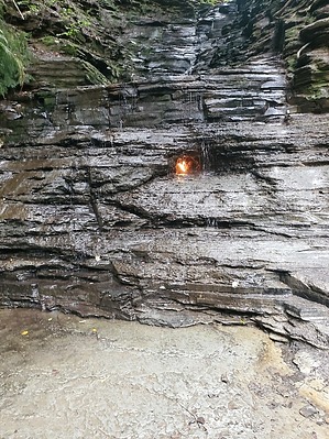
A really great hiking area and also a song by the Bangles
by Mike_W

 Likely In-Season!
Overview
Chestnut Ridge Park is a 1,150-acre park located near Orchard Park, New York, South of Buffalo. This is one of the largest County parks in the United States and was built in 1926. There are picnic areas, playgrounds, historic stone buildings, many hiking trails, and more. One of the main attractions of this area is the Eternal Flame, which is on the Southeast end of the park. There is a slow natural gas leak behind a waterfall area, which was lit and can stay lit for a very long time. The hike I describe starts at the North end of the park and loops around to view the Eternal Flame and then back to the North end.


Hike
Park in the lot on the North end of the park, and walk South along the road. After about 1/4 mile, look for Blue marker #1 on the right side of the road. This trail is mostly forested the entire way, which provides some nice shade. The first 2 miles of trail are rolling hills and you should be able to follow the numbered blue markers as they count upward. At about 3.25 miles, you'll reach a trail junction. Stay left here and go down the slope. At about the 3.4 mile mark, you'll see a cliff and from here the Eternal Flame may be visible from a distance if you look down and to the right. I explored the area to see if there was an easy way to get down into the lower ravine, but I didn't see a safe way to go. From here, you'll see a trail heading up and to the East. Follow this trail for roughly 500 feet and you'll see an old broken picnic table. This table is still usable and this isn't a bad place to take a break.
remove free decal offer
From the picnic table area, you should see a faint trail through the grass which heads over to the main trail. Take this trail 100 feet or less and this will intersect the main trail. Turn left and continue up the hill. After you have hiked a total of 3.6 or 3.7 miles you will see the intersection of the Eternal Flame trail, which is a short trail that leads down to the bottom of the ravine and South toward the Eternal Flame. Take this trail, following the "flame" symbols. When you get to the bottom of the ravine, turn left and follow the trail until you reach the end. After periods of rain, there will be a waterfall, and most likely you will also see the flame which is recessed in a hole behind the waterfall. I believe I have seen the flame blow out because of strong wind or someone purposely putting it out. It can be re-lit if that happens, and I'm not sure how frequently that happens.

After viewing the Eternal Flame, head back North along the ravine. Instead of going up the same way you came, you should see orange numbered markers on a trail branch heading North, which is the route you should take. From here back to the parking area, there are some rolling hills with one longer uphill section and multiple downhill sections. After hiking a total of 6.8 miles, you will look for a branch leading to the left. It is unmarked but it probably should be marked "to Chestnut Ridge trailhead" because I'm sure not having a sign here causes a lot of confusion. This is where having a GPS device is helpful. Follow this branch Northwest and then North until you reach the trailhead.

References
.gov CHESTNUT_RIDGE.pdf

2023-09-01 Mike_W


    Check out the Official Route and Triplog.
    Leave No Trace and +Add a Triplog after your hike to support this local community.
    WARNING! Hiking and outdoor related sports can be dangerous. Be responsible and prepare for the trip. Study the area you are entering and plan accordingly. Dress for the current and unexpected weather changes. Take plenty of water. Never go alone. Make an itinerary with your plan(s), route(s), destination(s) and expected return time. Give your itinerary to trusted family and/or friends.

     Permit $$
    None


     Directions
    or
     Road
    Paved - Car Okay

    To hike
    From anywhere in the Greater Buffalo, New York area, take I-90 West toward Erie, PA, and take the exit for US-219 South, toward Orchard Park / Springville.
    Stay on US-219 S
    5.3 mi

    Take the exit toward NY-240/NY-277/Armor Duells Rd/Chestnut Rdg Pk
    0.3 mi

    Merge onto New Armor Duells Rd/New Armour Rd
    0.7 mi

    Turn right onto NY-277 S
    1.4 mi

    Turn right onto Newton Rd
    0.3 mi

    Turn left
    200 ft

    Chestnut ridge trailhead
    Orchard Park, NY 14127
    page created by Mike_W on Sep 01 2023 9:53 am
     90+° 8am - 6pm kills
    helpcorrectionissue

    end of page marker