 Route Editor

| Guide | ♦ | 1 Triplog | 0 Topics |
details | drive | permit | forecast | map |
stats |
photos | triplog | topics | location |
| 20 | 1 | 0 |
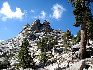
You'd be silly to miss this view! by chumley However, I didn't hike the Twin Lakes Trail from Lodgepole, only covering 5.5 mile section between Ranger Lake, and the JO Pass Trail junction at Clover Creek. So I've simply extracted this portion of the trail and named it for its primary feature & Silliman Pass.
The ascent leaves the shelter of the forest and begins to climb a largely exposed granite mountainside. The trail is masterfully built, with switchbacks as needed, and large rock walls created to hold the trail, in the same way that roads are built across Rocky Mountain passes. The exposed terrain offers amazing views to the east, exposing the Sierra Crest about 12 miles away, featuring some recognizable landmarks and peaks including Mt. Farquhar, Mt. Brewer, Table Mountain, Midway Mountain, and Milestone Mountain. The trail manages to take advantage of the shade of the few trees that grow on this hillside, occasionally dipping into a wooded area with softer footing and shrubbery. After about 1.5 miles and 1000 feet, you reach the pass, a relatively open area, with expansive views to the east. Short off-trail climbs to nearby Twin Peaks to the north or to an unnamed peak to the south give better views in all directions, including to the Twin Lakes below the pass to the west. From the pass, the trail begins a steady switchbacking descent down 750 feet in about a mile. A spring just below the pass feeds a small creek that crosses the trail several times and keeps the trail in well shaded forest most of the way down to Twin Lakes. The two lakes couldn't be further from twins. The big lake is a large clear body of water with a great view of open granite above, while the little lake is a smaller, grassy lake, with much more foliage around it, though a great view of Twin Peaks above it. There are numerous camping areas near Twin Lakes, including a couple of bear lockers, and a pit toilet. Seriously, a toilet! This probably says a lot about how popular the Twin Lakes area is. There are no campfires allowed here though, so if you plan to camp here, make sure you have a stove! After descending from the pass to the lakes, you might think you are "off the mountain", but the trail continues from the Twin Lakes area downhill for another 1000 feet, over about a mile and a half. This is also a steady decline, with some wide, easy switchbacks, some sheltered forested areas, and some open fields of granite. The trail is very popular however, so it is well maintained and footing is never a problem. At the bottom, the trail reaches a junction with the JO Trail and a nice campsite at Clover Creek. Heading downstream takes you to the popular Cahoon Meadow and the Twin Lakes trailhead at Lodgepole. Uphill takes you to JO Pass and Rowell Meadow. Check out the Triplog. Note This is a moderately difficult hike. Leave No Trace and +Add a Triplog after your hike to support this local community. One-Way Notice This hike is listed as One-Way. When hiking several trails on a single "hike", log it with a generic name that describes the hike. Then link the trails traveled, check out the example. | ||||||||||||||||||||||||||||||||||||||||||||||||||||||||||||||||||||||||||||||||||||||||||||||


