Route Editor

| Guide | ♦ | 14 Triplogs | 0 Topics |
details | drive | no permit | forecast | 🔥 route |
stats |
photos | triplogs | topics | location |
| 164 | 14 | 0 |
Canyons are inherently risky. Flash floods occur without notice on sunny days. Technical skills & surrounding topography knowledge required yet does not eliminate risk.
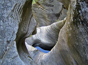
Don't fear the keeper by nonot  Overview OverviewA short, technical drop into the headwaters of WCC. This canyon has seen 10 registered descent parties over the last 3 years. Don't kid yourself to imagine that any help will be coming along, you need to be a self-reliant party. DANGER THIS CANYON CONTAINS KEEPER POTHOLES! DO NOT ENTER THIS CANYON ALONE OR UNPREPARED! IF WATER LEVELS ARE LOW YOU MIGHT BECOME TRAPPED IN A KEEPER WITH NO WAY TO CLIMB OUT! YOU NEED TO HAVE A PLAN FOR THIS!
Always check weather conditions before entering a canyon, you don't want to be trapped in these places during a flash flood! You are responsible for evaluating your own abilities and whether you are a danger to yourself or to your party. Ask yourself if you are really ready to attempt this canyon before committing. Gear You will need a full set of normal canyoneering gear: harness, helmet, carabiners, rappelling device. Add to that an optional wetsuit and at least 2x150 ft ropes. 2x200s worked out well. Be prepared for keeper potholes. The canyon was dry after weeks of good rains other than the keeper and nonkeeper potholes. A wetsuit may not be necessary for summer. However, if you become kept you will get very cold very quickly, so a shortie may be advisable in summer, more needed in spring or fall. History First descent claimed by Joe DeSalme. He and Sara DeSalme asked in the canyon register that the canyon be kept secret. Since it has been published I think their secret's out, but they're in the book as well so... Hike On a nice September afternoon, we departed from the road heading downhill ENE. We encountered a cliff band and headed slightly SE to bypass it and then route-found our way to canyon bottom to the E. A short few hops over dead logs and through trees and brush brought us to a 15-foot drop into skanky water. You can avoid this first downclimb by bypassing on canyon left. After going around the pool we dropped back into the bottom 50 ft downcanyon and signed into the trail register. We suited up here. After the register is a 6 foot downclimb into a deep, semi-keeper pothole. Since there is no rappel rigged once you're in it you're committed. Be prepared to deal with this first obstacle as a team, don't let it catch your group off guard! After this, a few downclimbs are encountered through some narrow cracks. When you see webbing from a glue-in ring bolt on right (LDC), you've reached the technical part. The first drop is a 10 ft drop followed by a 5 ft traverse to a 20 ft rappel, which ends free-hanging into a big, shallow, disgusting pothole. Mmmm, yummy...you wanted to be a canyoneer! Climb out of the gunk on canyon left (LDC) and await the rest of your party. On the backside of the rock on right (LDC) from the skanky pothole is another webbing clad ring glue-in bolt for the next two-stage section, the Blue Canyon Cult special. Rig ropes for their full-lengths, 150 ft at least. Off this bolt, rap 60 ft onto a short gravel-filled slot, then get some slack and walk through a bowl. Before you proceed, evaluate the next portion carefully. You can rap down the chute into the deep keeper or you can try to find another route to avoid it (while still staying on rappel). Use your wits and be safe! Have a backup plan if you get kept! If you misstep you're probably going to pendulum into the keeper. Hopefully, you can avoid smashing into the wall. After you have obtained the ledge on the far side of the keeper, be careful setting up the continuation of your rappel. Don't pull your ropes when you reach this lip! You will need to continue down another 30 feet, but plan carefully!! Due to all the angles and lack of straight lines, you could be in for quite a whipper if you get it wrong! After all are safely down on terra firma you can finally pull your ropes, if you used 200 ft ropes, on left (LDC there is a ledge which makes for a great rope pull as you have sight of the anchor. I have to comment that this was one of the more awkward sequences I've faced in a canyon, this would be a poor choice of canyon for a beginner. A big group could stage people at several points along this sequence, but most of these spots allow the offering of only minimal assistance. After a short walk of 30 feet, you will find a slung tree. You can rappel this (40 feet?) or climb around and down (not recommended, I rolled a couple 1000lb+ stones on my way down, the ground is unstable). After another few dozen yards over some dead trees and through bushes, you will reach the final rappel, a 50-60 ft or so rappel from a slung ring bolt on right (LDC). This rappel is against a vertical wall. After this is a bit of a bushwhack, albeit not too bad until you reach WCC. The exit and trip distance statistics will be described as we did it, although I HIGHLY recommend simply heading down WCC to either exit at Maxwell (with shuttle) or the Point Trail (shuttle or long road walk). OK, after just a smidge more than a full mile downstream WCC (if you hit Tramway you went too far), is a side canyon with NO trail that indicates any access. Along the way, you may find some petroglyphs. The climb up the exit canyon is steep; full of bushes, logs, and mud; and full of sharp thorny trees at the very top, but if you relent you can find your way out of WCC. Hint: at every decision point on the climb out go LEFT (LUC). With any luck, you should find an old road that reaches the canyon bottom coming in off the right (west) wall (LUC). Follow the road until it ends, then climb up the hill on left (LUC) until you find another road. Turn right on this road until you reach the road you drove in on (142F). Turn left until you find your vehicle. It rained a bit on us on the climb out. I think every part of my body got muddy and scratched on the climb out, your experience may vary... Note decent clearance is needed to obtain the trailhead, more than an average sedan. Some mud. Remember, don't do this canyon alone or unprepared. I believe the R rating on this canyon is deserved. Surprisingly, after all the rains we've had the keepers were still in keeper mode. Note The trip motto/description is based on a comment left in the canyon register by someone using a humorous alias. Check out the Official Route and Triplogs. Leave No Trace and +Add a Triplog after your canyon trip to support this local community. | ||||||||||||||||||||||||||||||||||||||||||||||||||||||||||||||||||||||||||||||||||||||||||||||||||||||||||||||||||||||