 Route Editor

| Guide | ♦ | 56 Triplogs | 0 Topics |
details | drive | no permit | forecast | route |
stats |
photos | triplogs | topics | location |
| 107 | 56 | 0 |
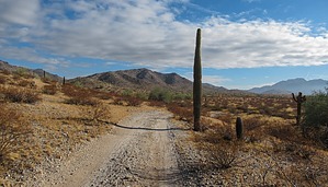
The trail for the rich and famous by mt98dew  Warning WarningThere is some confusion on whether these trails are open to the public. There are signs posted at the Copper State Bike and Hike TH, as well as random locations along the trails stating that this is for residents and guests only. However, I have reached out to the City of Goodyear and they have said that this is not the case. Overview The Park Ave Trail is one of 24 trails that make up the Estrella Foothills Trail System. There are currently two TH’s for this system. The Copper State Bike and Hike and the Estrella Foothills Community Park. The Park Ave Trail starts from the Estrella Foothills Community Park. In addition to being a TH for some of the EF trails, the park also has picnic tables, baseball and soccer fields, a “pump track” (a hilly jump section for bikes), bathrooms, and a drinking fountain. There is enough parking for 30 cars. The TH is a bit removed from the parking area so one must walk about 0.2 miles to the northeast, circumventing a baseball field. There is an old whiteboard that will help identify the TH. At the TH there will be a carsonite marker with several abbreviations on it. One is the PA (Park Ave) Trail. This is the beginning of the Park Ave Trail.
The Park Ave Trail starts by heading north along a wide dirt track. It immediately crosses a sandy wash. In 0.15 miles it will reach another carsonite marker. The PA trail will turn east at this marker. Initially, the trail will twist and turn, hitting all four directions of the compass as it navigates through some low-lying hills. Around 0.7 miles it will swing wide and wrap around the south side of the hills. At the same time, the sandy wash that we crossed in the beginning will begin to border this trail. Its proximity to the trail will vary as you continue, but it and the vegetation that encompasses it will always be in sight. At point 0.84 the Park Ave Trail intersects with the Rum Runner Trail (RR). The PA trail will make a hard right onto a dual track heading east. The hills, which defined the beginning of this trail fall away and you get what I consider to be the Estrella Foothills rising off to the north and the wash, along with miles of flat desert views to the south. At 1.15 the PA will leave the dual track and become a single track again. There will be some minor curves in the trail, but it pretty much maintains its eastward direction heading toward the Estrella Mountains seen in the distance. At 1.58 the trail junctures with the JR trail. (Oddly enough, the map for this system refers to this trail as the Pirate Cove Trail. Not sure how they get JR from Pirate Cove). At 1.71 miles the trail will end, reaching the Estrella Mountain Regional Preserve (EMRP). Synopsis Though a bit removed from the valley this trail offers several caveats that may make it worthwhile. First, it is a great intro to the Estrella Foothills Trail System providing a couple of important links to the rest of the trails. Secondly, this trail offers a nice option for accessing some of the more removed trails within EMRP. Thirdly, it is part of the Maricopa Trail System. The Maricopa Trail is a 300-mile loop designed to hit all of the county parks. This trail is part of an isolated segment that extends from this loop to the Buckeye Hills County Park.
Check out the Official Route and Triplogs. Leave No Trace and +Add a Triplog after your hike to support this local community. One-Way Notice This hike is listed as One-Way. When hiking several trails on a single "hike", log it with a generic name that describes the hike. Then link the trails traveled, check out the example. | |||||||||||||||||||||||||||||||||||||||||||||||||||||||||||||||||||||||||||||||||||||||||||||||||||||||||||||||||||||||||||||||||||||||||||||||||||||||||||||||||||||||||||||||


