Route Editor

| Guide | ♦ | 1 Triplog | 0 Topics |
details | drive | no permit | forecast | route |
stats |
photos | triplog | topics | location |
| 14 | 1 | 0 |
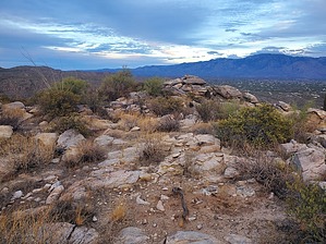
There were thorns and there were dales by Mike_W  Overview OverviewThornydale Mountain, elevation 3,575, is a small mountain on the south side of the Tortolita Mountain range. There is no trail and there's private land nearby which you'll need to be aware of. This hike is a bushwhack if you take the most direct route. This area may not be accessible for many more years because it appears that a development company now owns the land. Will there be an easement for hikers in the future or will developers destroy this mountain selling pieces off to the highest bidders? Warning There were some private roads north of my starting point for "residents only", and I walked parts of these roads on the way back because it was already dark. I suspect these roads are not used too often because they only appear to serve a few parcels many of which may not even be developed.
Start on the road you parked on and head north for about 400 feet. When your road turns to the east, this is a good place to get off the road. You'll see scattered clear areas but there's a lot of brush and cactus to weave around. About 1/4 mile in front of you to the north is a small rocky hill. This, of course, is not Thornydale Mountain. I found it easier to stay west of this hill. Somewhere near this rocky hill, I found a barbed wire fence that only went a short distance up the rocky hill. I stepped over the fence where there was a low section near the very top and proceeded north. There were no private property signs here so I felt safe to continue forward. After hiking a total of 0.4 miles, I encountered a dirt road. I followed it northeast for a short distance and then when I realized the road was not going where I needed to go, I got off the road and continued north. There was a rocky area with less brush and the bushwhacking was a little easier here from what I remember. After hiking a total of 2/3 of the mile, I saw a wash up ahead. I found a cow carcass on the south side of the wash but didn't get too close. I walked to the middle of the wash and saw some rocky cliffs in front of me. From here, I found it easier to walk west and southwest for at least 200 feet before I could find an easier route heading north. A few minutes after leaving the wash, I had a nice view of Thornydale Mountain to my north. I found it easiest to hike perpendicular to the ridgeline coming in from the east and once I got on top of the ridgeline, I crossed it and followed the ridgeline to the top, staying on the western side of the ridge where it wasn't as rocky. There were some great views from the peak of some of the Tortolita mountains and the sun getting low in the sky later in the afternoon. I could see the homes below, basically on both sides of the ridge. There were homes much closer to the western side than the eastern side. On the way down, I followed a similar route but stayed more toward the center of the ridgeline. When I eventually got back to the wash, I decided to follow it south/southwest for 400 or 500 feet. When the road curved to the right, I decided to get off the road and head further south which was in the direction where I parked. It was a light bushwhack in this area. Shortly after this, I ran into a road. It was already dark at this point so I ended up taking the road southwest and then southeast to the junction of the road where I parked. I did have to duck under a gate and at this point, I did not care that it was a "private road" for residents only. I didn't see a single person anyway. All in all, it was a good hike and I would like to explore the area again sometime to see if there are better routes or even trails anywhere. Gate Policy: If a gate is closed upon arrival, leave it closed after you go through. If it is open, leave it open. Leaving a closed gate open may put cattle in danger. Closing an open gate may cut them off from water. Please be respectful, leave gates as found. The exception is signage on the gate directing you otherwise. Check out the Official Route and Triplog. Leave No Trace and +Add a Triplog after your hike to support this local community. | ||||||||||||||||||||||||||||||||||||||||||||||||||||||||||||||||||||||||||||||||||||||||