Route Editor

| Guide | ♦ | 2 Triplogs | 0 Topics |
details | drive | no permit | forecast | route |
stats |
photos | triplogs | topics | location |
| 64 | 2 | 0 |
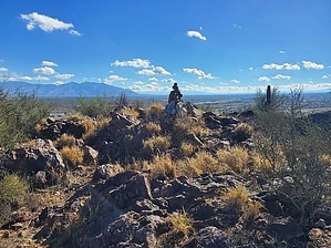
Not that I'm complaining, but where did all the prickly pear go?? by Mike_W  Overview OverviewThe Rillito Benchmark, at an elevation of 2,504 feet, is in Marana, AZ just west of I-10 near the Avra Valley exit. There's no official trail, but I found a fairly good "use trail" going up the North face which appears to continue along the ridgeline. There's very little brush on this mountain, which is unlike many nearby mountains. Mainly, I saw some palo verde trees, creosote, and some saguaros. I don't remember seeing a single prickly pear or cholla the entire way. Hike From the parking area on the north side of the mountain, walk about 200 feet to the east along the bike path. From here, you should see a use-trail heading south and going up toward the high point. I believe these trails are animal trails and therefore there should be many routes going up. The entire time I was climbing, I don't remember having to squeeze through any brush at all. I did have to zig-zag around some larger rocks. Eventually, I reached the ridgeline, then made a left turn, and followed that ridgeline to the summit.
I continued following the ridgeline southeast going down which was pretty rugged. There were a few spots where I needed to drop to the left or right to get around cliffs. I found a nice 10-foot wide shelter area under some huge boulders very close to the ridgeline. I could imagine native Americans using this area for shelter or for hiding out. Just below this shelter area, I was walking across some rocks and I heard a soft rattle from a snake that sounded like it was coming from under the ground where I was walking. The rattle was very soft and I never saw the snake. I kept walking forward slowly and listened again, heard the soft rattle one more time, and then it stopped because I was far enough away. I thought it was a bit unusual to hear a rattle in mid to late November. After continuing I eventually got down to a saddle and then continued climbing up and shortly reached a 20-foot cliff. I traveled to the right and found a fairly easy way to get above the cliff, and within a few minutes, I was at the secondary high point which was at roughly 2,405 feet elevation. Before getting to the peak, I found some lights that appeared to be installed pointing toward a tree. I thought this was odd and didn't know why these lights would be there. Further ahead, I found a lot of trash and items that were probably used by drug runners. Items include a metal grate for cooking, a pair of tongs, an empty box for binoculars which had a range of 1,000 yards, blankets, a sleeping bag, a medical reference book, a pair of scissors, several metal poles probably used to make a small shelter, and a lot of discarded trash in various piles, with some of it in a metal trashcan(?). One thing is for sure, whoever was up here using the binoculars was probably up to no good. Next, I continued following the ridgeline down from the high point, looking for the trincheras that were mentioned in another trip report. I saw some places that looked like they could have been trincheras but these structures appeared to be disturbed over the years. I continued exploring the area and then when done I started heading northeast toward the Santa Cruz River. There was not a lot of brush and I only needed to zig-zag a bit to avoid the steep drops or larger rocks. When I got close to the bottom, the slope got a bit steeper but was able to weave and find several good ways to get down. Near the bottom, I found some old Indian grinding holes that were filled with water since it just rained the day before. When I reached the bottom, I ran into the bike path/walking path and took that north and northwest back to the parking area. All in all, this was an excellent hike and I would do it again someday. Anyone who lives in NW Tucson and enjoys off-trail hikes should do this hike!
Check out the Official Route and Triplogs. Leave No Trace and +Add a Triplog after your hike to support this local community. | |||||||||||||||||||||||||||||||||||||||||||||||||||||||||||||||||||||||||||||||||||||