Route Editor

| Guide | ♦ | 1 Triplog | 0 Topics |
details | drive | no permit | forecast | route |
stats |
photos | triplog | topics | location |
| 56 | 1 | 0 |
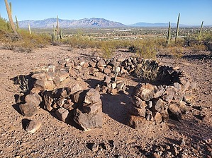
a real trinchera or modern day replica? by Mike_W  Overview OverviewPeak 2483, with an elevation of 2483 feet, which appears to be on US Forest Service land is almost completely surrounded by private land, but I believe there are 2 good ways to hike to this high point (explained below), along with the nearby Beacon Hill which contains some fenced in radio towers. There are some great views of Tucson from these high points, and you probably won't see a single person the entire way, except for possibly some people near the cave area. Hike Down at my starting point (see route), I saw some workers working on a barbed wire fence which was 100 feet west of the parking area. The fence workers told me it was OK to pass through so I started out by exploring the 2 caves which are visible from the trailhead. I also noticed a gap in the fence which probably was intended to allow people through to explore the unique cave area. It's too bad that there was a lot of graffiti inside the caves. It takes away from the real nature and cheapens the area. Anyway, after exploring the caves, I hiked to the north and found a use-trail going above and around the cave areas. I even found an upper cave entrance that could potentially be dangerous but was another way to get down into the cave from a higher level. I kept going up and within a few minutes, I reached the top of a rocky hill. Technically, this rocky hill appears to be on private property, but if you walk west toward the saddle, from this point you should be on Pima County land or USFS land. In either case, there should be any problem from this point forward.
From the rocky hilltop, looking to the northwest, I could see Peak 2483 which was 200 feet above where I was. I kept moving forward, heading down to a saddle, and then climbed up toward Peak 2483. There wasn't much brush to go around, and it was easy to find clearings and good ways to proceed. It felt like I was on a use-trail either made by people or animals. I reached the summit in probably 20 minutes after leaving the cave area and found a registry that was not in such an obvious place. Since the year 2000, I only saw 5 parties listed in the registry which is much less than I expected. The last entry was over 6 years ago (Nov 2017). I believe some more recent hikers did not see the registry. I signed it and added a small pile of rocks so that it would be more visible. From the summit, I climbed north down to a low saddle and found what appeared to be a large trinchera in good condition. It was hard to tell whether this trinchera was traditional/original or a modern-day replica. Anyway, it was a great photo, and I continued north up to Beacon Hill where I saw a use-trail up higher, and a dirt road running north and all the way down the north side. The road led over to some antennas and satellite dishes inside a fenced area. I walked around the fence, and back to the road then took it further north and slightly downhill. Up ahead there were more antenna towers. I took a photo of these towers and then turned around to head back. According to Google Maps and "Street View", there's a sign at the bottom of the road on the north side that says 'Private Property' with a closed gate. I didn't come from that way and I didn't see anyone else on the hill. The only private property signs I saw were on the perimeter of the enclosed fences around the antennas, so I would guess that walking the road isn't a problem. After turning around, I walked the road back up to the fenced area at the high point and then saw some cairns heading back down to the saddle I was at earlier. I took a slightly different route to the saddle. There were many good ways to go. Then, instead of summiting Peak 2483 again, I stayed left of the summit and stayed about 250 feet below the peak and wrapped around to the saddle southeast of Peak 2483. In this area, the brush got a little thicker and I saw more cholla, but there were ways to zig-zag through it and I didn't get a single thorn. If you stay close to the rocky hill, you may find it to be clearer of any brush. I decided to hike up to the saddle west of the rocky hill that I first summited in the beginning. There was less brush here. Then, I took basically the same route back down to where I parked. By this time, the fence workers were gone and I walked through the gap in the fence. All in all, this was an interesting hike with some great views. The brush only got a little thick in the area where I went around Peak 2483 on the way back. Aside from that area, it was almost like an open-country hike. Gate Policy: If a gate is closed upon arrival, leave it closed after you go through. If it is open, leave it open. Leaving a closed gate open may put cattle in danger. Closing an open gate may cut them off from water. Please be respectful, leave gates as found. The exception is signage on the gate directing you otherwise.
Check out the Official Route and Triplog. Leave No Trace and +Add a Triplog after your hike to support this local community. | ||||||||||||||||||||||||||||||||||||||||||||||||||||||||||||||||||||||||||||||||||||||||